
Photo from Pagasa
MANILA, Philippines — Tropical Depression Maymay is slowly approaching the country’s landmass and the state weather bureau warned Tuesday of possible heavy rains and strong winds in parts of northern and central Luzon.
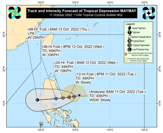
According to the 11 a.m. weather bulletin of the Philippine Atmospheric, Geophysical and Astronomical Services Administration (Pagasa), Maymay was last located 285 kilometers east of Casiguran, Aurora, carrying with it winds of up to 45 kilometers per hour and gustiness of 55 kph.
From Tuesday to Wednesday morning, Pagasa said Cagayan, Isabela, Batanes, and Apayao could anticipate moderate to heavy rain which may become intense occasionally.
On the other hand, Aurora, Abra, Kalinga, Mountain Province, and Ilocos Norte could see light to moderate and heavy rains, Pagasa added.
Tropical Cyclone Wind Signal (TCWS) No. 1 remains raised over Isabela, Quirino, and Nueva Vizcaya in the Cagayan Valley region; Aurora and Nueva Ecija in Central Luzon; and General Nakar, Infanta, and Polillo Islands in Quezon province.
READ: LPA develops into Tropical Depression Maymay; Signal No. 1 up in 8 areas
Pagasa said strong winds are expected in areas under TCWS No. 1 as it hoisted Marine Gale Warning No. 4 over the northern seaboards of northern Luzon and the eastern seaboard of central and southern Luzon.
Maymay is predicted to maintain its strength as it moves southwestward within the next 48 hours, the state weather service said, further warning that areas affected by the tropical depression must stay alert for possible flooding and rain-induced landslides.
Pagasa likewise urged the public and disaster risk reduction and management offices in affected areas to prepare and take necessary measures to protect life and properties.
