LPA develops into Tropical Depression Maymay; Signal No. 1 up in 8 areas
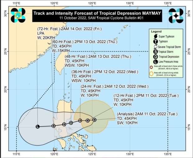
Photo from Pagasa
MANILA, Philippines — A low-pressure area within the Philippine area of responsibility (PAR) on Tuesday developed into a tropical depression – locally named Maymay, prompting state meteorologists to place eight areas under Tropical Cyclone Wind (TCWS) Signal No. 1.
The Philippine Atmospheric, Geophysical and Astronomical Services Administration (Pagasa) said that Maymay was last spotted 300 kilometers east of Casiguran, Aurora, packing maximum sustained winds of 44 kilometers per hour (kph) and gustiness of up to 55 kph.
Specifically, the state weather bureau hoisted TCWS No. 1 on the following areas:
- Aurora
- Isabela
- Quirino
- Nueva Vizcaya
- Nueva Ecija
- General Nakar (Quezon)
- Infanta (Quezon)
- Polillo Islands

Pagasa said these areas can expect heavy rains as well as strong winds this Tuesday through Wednesday morning.
“Kung hindi magbabago ang pagkilos ng bagyong Maymay, ay inaasahang ito ay magla-landfall sa vicinity ng southern portion ng Aurora, o sa northern portion ng Quezon bukas ng hapon o gabi,” said Pagasa weather specialist Aldczar D. Aurelio in the agency’s morning weather forecast.
(If Maymay’s movement does not change, it is expected to make landfall in the vicinity of the southern portion of Aurora or the northern portion of Quezon tomorrow afternoon or evening.)
According to Aurelio, Maymay’s projected track is similar to Super Typhoon Karding’s with the eye of the tropical depression seen to pass through Central Luzon. However, he added that Maymay is likely to remain a tropical depression.
Meanwhile, Ilocos Norte, Apayao, Abra, Kalinga, Mountain Province, Ifugao, Batanes, Cagayan, and Isabela may also experience the effects of Maymay as these areas were forecast to have cloudy skies with scattered rainshowers and thunderstorms, Pagasa noted.
As for Metro Manila and the rest of the country, the state weather service said partly cloudy to cloudy skies with isolated rainshowers due to localized thunderstorms may be anticipated.
Pagasa likewise revealed that it is also monitoring a second tropical depression outside of PAR. It will be named Neneng once it enters PAR by Thursday. As of Tuesday morning, it is located 1,730 kilometers east of eastern Visayas, packing maximum sustained winds of 45 kph and gustiness of up to 55 kph.
RELATED STORY
Pagasa: Rain expected in parts of Northern Luzon, fair weather elsewhere