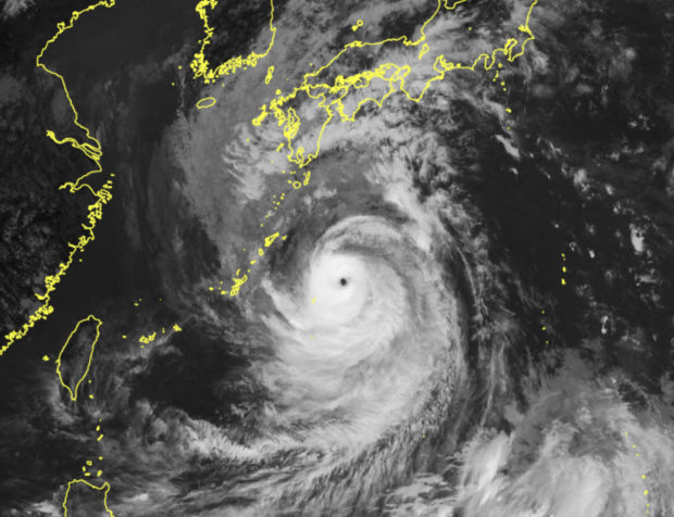
This handout photo taken and released on September 17, 2022 by the Japan Meteorological Agency shows satellite imagery shows Typhoon Nanmadol located near the southern remote islands of Japan. (Photo by Handout / Japan Meteorological Agency / AFP) / – Japan OUT / XGTY – Japan OUT / —–EDITORS NOTE — RESTRICTED TO EDITORIAL USE – MANDATORY CREDIT “AFP PHOTO / Japan Meteorological Agency” – NO MARKETING – NO ADVERTISING CAMPAIGNS – DISTRIBUTED AS A SERVICE TO CLIENTS
FUKUOKA — Thousands of people were in shelters in southwestern Japan on Sunday as powerful Typhoon Nanmadol churned towards the region, prompting authorities to urge nearly three million residents to evacuate.
The Japan Meteorological Agency (JMA) has issued a rare “special warning” for the Kagoshima region in southern Kyushu prefecture — an alert that is issued only when it forecasts conditions seen once in several decades.
By Sunday morning, 25,680 households in Kagoshima and neighbouring Miyazaki were already without power, while regional train services, flights and ferry runs were cancelled until the passage of the storm, local utilities and transport services said.
The JMA has warned the region could face “unprecedented” danger from high winds, storm surges and torrential rain.
“Maximum caution is required,” Ryuta Kurora, head of the JMA’s forecast unit said on Saturday.
“It’s a very dangerous typhoon.”
“The wind will be so fierce that some houses might collapse,” Kurora told reporters, also warning of flooding and landslides.
So far, 2.9 million residents in Kyushu have been issued with evacuation warnings, according to the government’s Fire and Disaster Management Agency, and Kagoshima officials said over 8,500 people were already in local shelters by Sunday morning.
The evacuation warnings call on people to move to shelter or alternative accommodation that can withstand extreme weather.
But they are not mandatory, and during past extreme weather events authorities have struggled to convince residents to take shelter quickly enough.
Kurora urged people to evacuate before the worst of the storm arrived and warned that even in sturdy buildings residents would need to take precautions.
‘Highest caution possible’
“Please move into sturdy buildings before violent winds start to blow and stay away from windows even inside sturdy buildings,” he told a late night press conference.
By Sunday morning, bullet train operations in the area were halted, along with regional train lines, and NHK said at least 510 flights had been cancelled.
“The southern part of the Kyushu region may see the sort of violent wind, high waves and high tides that have never been experienced before,” the JMA said Sunday, urging residents to exercise “the highest caution possible.”
On the ground, a Kagoshima prefectural official told AFP there were no reports so far of injuries or structural damage but conditions were deteriorating.
“The rain and wind are getting stronger. The rain is so heavy that you cannot really see what’s out there. It looks all white,” he said.
At 9:00 am (0000 GMT), the typhoon was 80 kilometres (50 miles) southeast of Japan’s Yakushima island, and packing gusts up to 252 kilometres per hour.
It is expected to make landfall in Kyushu on Sunday evening, before turning northeast and sweeping up across Japan’s main island through early Wednesday.
Japan is currently in typhoon season and faces around 20 such storms a year, routinely seeing heavy rains that cause landslides or flash floods.
In 2019, Typhoon Hagibis smashed into Japan as it hosted the Rugby World Cup, claiming the lives of more than 100 people.
A year earlier, Typhoon Jebi shut down Kansai Airport in Osaka, killing 14 people.
And in 2018, floods and landslides killed more than 200 people in western Japan during the country’s annual rainy season.
Scientists say climate change is increasing the severity of storms and causing extreme weather such as heat waves, droughts and flash floods to become more frequent and intense.
RELATED STORIES
Pagasa: ‘Nanmadol’ to enter PAR Friday afternoon, may become super typhoon
Typhoon Nanmadol to sideswipe PAR Friday night, but won’t stay for long – Pagasa