Typhoon Nanmadol to sideswipe PAR Friday night, but won’t stay for long – Pagasa

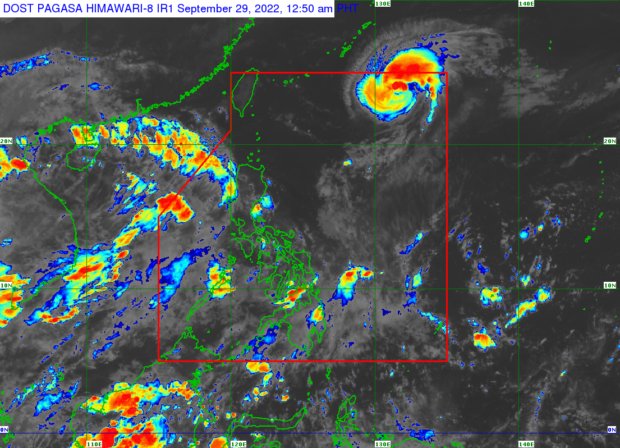
Weather satellite image from Pagasa.
MANILA, Philippines — Typhoon Nanmadol is expected to enter the Philippine area of responsibility (PAR) on Friday night, but state meteorologists do not expect it to stay for long.
According to the Philippine Atmospheric, Geophysical, and Astronomical Services Administration (Pagasa), Nanmadol is only seen grazing the northeastern corner of the PAR. While within the country, the typhoon will be called “Josie.”
As of Friday afternoon, Nanmadol was 1,445 kilometers east-northeast of extreme Northern Luzon, packing maximum sustained winds of 175 kilometers per hour (kph) and gustiness of up to 215 kph. It was moving northwestward at a speed of 10 kph.
Forecasts show that Nanmadol will head northeast before perhaps recurving towards Japan, therefore, it is unlikely that it would have any direct impact on Pagasa, according to meteorologist Raymond Ordinario.
“Isang magandang balita, nakikita pa rin natin na tuluyan lamang itong dadaplis dito sa may corner o sa may kanto ng ating area of responsibilty kaya hindi ito magkakaroon ng direktang epekto sa anumang bahagi ng ating bansa, at hindi rin natin inaasahan na tatagal ito sa ating area of responsibility,” Ordinario said.
Article continues after this advertisementHowever, satellite images from Pagasa show that the trough or extension of Nanmadol is pulling the southwest monsoon – locally known as “habagat” – and bringing thick cloud bands over parts of Luzon and Visayas, particularly Southern Luzon and Western Visayas.
Article continues after this advertisementThe state weather bureau also said rain is highly possible in the said areas, especially in Palawan and Mindoro, because of the southwest monsoon. But for the rest of the country, fairer weather can be expected despite isolated rain showers, it added.
As for forecast temperature ranges in key cities across the country, Pagasa said Puerto Princesa in Palawan province might experience slightly colder weather – 26 to 31 degrees Celsius – amid cloudy skies. Metro Manila and Legazpi may feel temperatures between 25 and 32 degrees Celsius; Tuguegarao, 24 to 33 degrees Celsius; Laoag, 24 to 32 degrees Celsius; and Tagaytay, 22 to 31 degrees Celsius on Saturday, September 17.
For Visayas and Mindanao, Iloilo may have slightly lower temperatures due to the southwest monsoon, at 25 to 31 degrees Celsius. On the other hand, Cebu and Tacloban may experience a climate of 26 to 32 degrees Celsius, while Zamboanga may feel 25 to 32 degrees Celsius temperatures; Davao, 24 to 32 degrees Celsius, and Cagayan de Oro, 24 to 31 degrees Celsius also on Saturday.
Pagasa said no gale warning is raised over any part of the country’s waters.
RELATED STORY
Pagasa: Cloudy, wet Friday in parts of PH as typhoon nears PAR