Inday to exit tonight; tropical depression spotted outside PAR

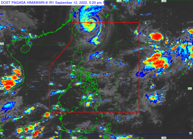
Pagasa says Typhoon ‘Inday’ (international name: Muifa) is expected to exit the Philippine area of responsibility by Monday night. (Photo from Pagasa.)
MANILA, Philippines — The Philippine Atmospheric, Geophysical and Astronomical Services Administration (Pagasa) on Monday afternoon said that Typhoon Inday (international name: Muifa) is already expected to exit the Philippine area of responsibility later (PAR) tonight.
According to Pagasa weather specialist Raymond Ordinario, as of 5 p.m., Inday is currently located 500 kilometers northeast of Itbayat, Batanes, with maximum sustained winds of 140 kilometers per hour (kph) with gustiness of 170 kph.
“Ito’y kumikilos pahilagang kanluran sa bilis na 15kph, halos 20 kilometers na lang [ito] mula sa boundary ng Philippine area of responsibility, kaya posible talaga mamayang gabi nasa labas na ito ng ating boundary,” Ordinario said.
(It is moving northwest at a speed of 15 kph, only about 20 kilometers from the Philippine area of responsibility boundary so it may be outside our boundary tonight.)
Article continues after this advertisementMeanwhile, a tropical depression was also spotted outside PAR, 1,776 kilometers east of Northern Luzon, traveling northwest at 10 kph with wind speeds reaching 40 kph and gusts of up to 55 kph.
Article continues after this advertisementOrdinario, however, explained that there is a slight chance for the cyclone to enter PAR as its forecast track is expected to continue to the north.
“So kung papasok man ito dadaplis lamang ito sa boundary ng PAR, at hindi natin ito inaasahang magkaroon ng direktang epekto sa ating bansa,” he said.
(So, if it enters, it will only pass through the PAR boundary, and we do not expect it to impact our country directly.)
Ordinario said it would be given the local name Josie if the cyclone entered PAR.
Gale warning, meanwhile, remains in effect over the seaboards of Batanes and Babuyan Islands.