Tropical depression outside of PAR to gain strength, arrive Wednesday night
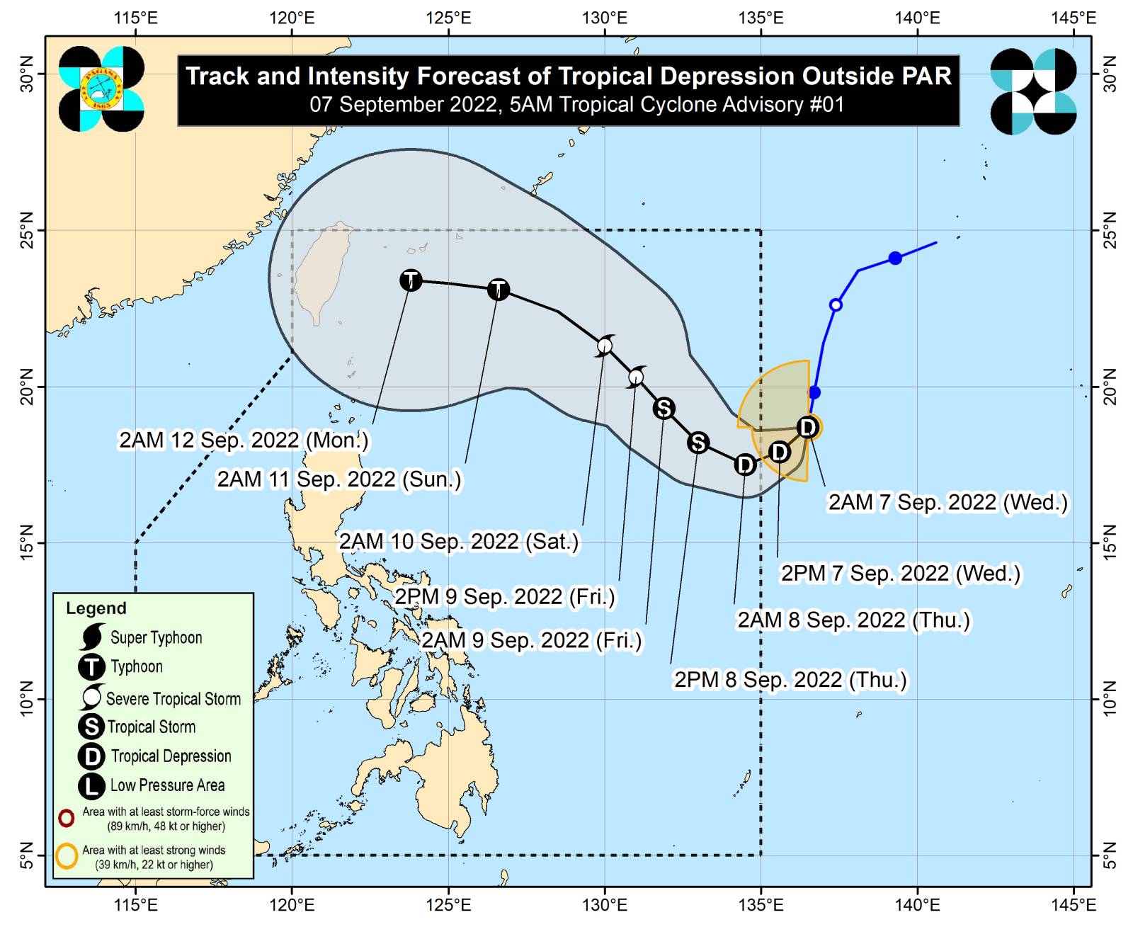
Pagasa’s track and intensity forecast of tropical depression outside of PAR
MANILA, Philippines — A tropical depression outside the Philippine area of responsibility (PAR) is expected to gain strength and be upgraded into a tropical storm on Wednesday, according to the state weather bureau.
The Philippine Atmospheric, Geophysical and Astronomical Services Administration (Pagasa) said that the cyclone is located 1,525 kilometers east of extreme northern Luzon and is moving southward at 20 kilometers per hour. It is expected to enter PAR either Wednesday night or Thursday morning.
As of Pagasa’s latest advisory, the tropical depression has maximum sustained winds of 55 kilometers per hour and a gustiness of up to 70 kilometers per hour.
“Within 36 hours ay posible itong mag-intensify pa into a tropical storm category at habang binabaybay nga nito itong karagatan, ay mayroong posibilidad na mag-intensify pa, or magpatuloy na mag-intensify, at maging typhoon, posible yan by Sunday,” said Pagasa weather specialist Grace Castañeda in the bureau’s public weather forecast.
(It is possible that it will intensify into a tropical storm within 36 hours. While it travels along the sea, it may even further intensify into a typhoon, possibly by Sunday).
Article continues after this advertisementAccording to Castañeda, the tropical depression will not have a direct effect on the country for Wednesday and it is not expected to make landfall during its stay within PAR.
Article continues after this advertisementThe overcast weather that Palawan, Western Visayas, Zamboanga Peninsula, Basilan, Sulu and Tawi-Tawi will experience is due to the intertropical convergence zone (ITCZ), resulting in cloudy skies with scattered rainshowers and thunderstorms, said Pagasa.
Metro Manila and the rest of the country can expect partly cloudy to cloudy skies with isolated rainshowers or due to either effects of the ITCZ in or localized thunderstorms, said the state weather bureau.
Pagasa listed these temperature ranges in the following cities and areas:
Metro Manila — 25 to 34 degrees Celsius
Baguio — 17 to 24 degrees Celsius
Laoag — 24 to 32 degrees Celsius
Tuguegarao — 25 to 34 degrees Celsius
Legazpi — 25 to 33 degrees Celsius
Puerto Princesa — 25 to 31 degrees Celsius
Tagaytay — 23 to 31 degrees Celsius
Kalayaan Islands — 26 to 31 degrees Celsius
Iloilo — 25 to 31 degrees Celsius
Cebu — 24 to 33 degrees Celsius
Tacloban — 25 to 33 degrees Celsius
Cagayan de Oro — 24 to 31 degrees Celsius
Zamboanga — 24 to 33 degrees Celsius
Davao — 25 to 33 degrees Celsius