Pagasa says may hoist Signal No. 2 as Super Typhoon ‘Henry’ to become ‘almost stationary’ by Friday
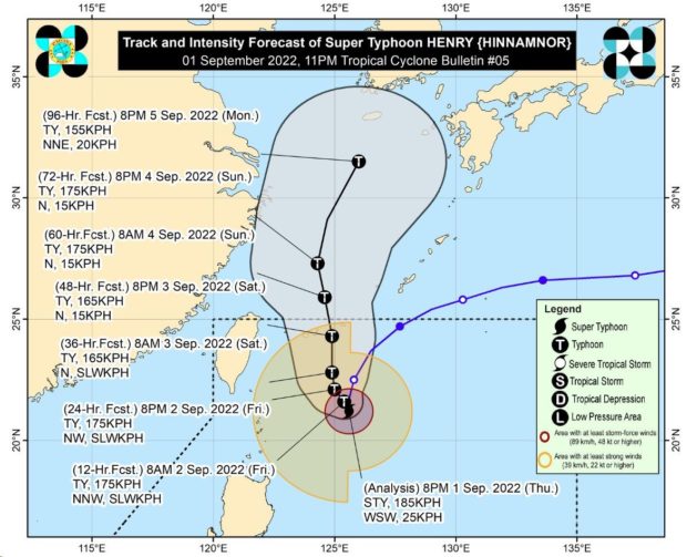
MANILA, Philippines — True to earlier forecast, Super Typhoon Henry (international name: Hinnamnor) was seen to be “almost stationary” over the Philippine Sea in the east of Batanes on Friday, and state meteorologists are not ruling out raising the storm signal to Number 2.
The center of the eye of Henry was last located 380 kilometers east of Itbayat, Batanes, packing maximum sustained winds of 185 kilometers per hour (kph), with gustiness of up to 230 kph, according to the Philippine Atmospheric Geophysical and Astronomical Services Administration’s (Pagasa) latest weather bulletin.
“Super Typhoon Henry is forecast to continue decelerating and may become almost stationary tomorrow morning. Henry may begin tracking slowly northwestward by tomorrow afternoon before eventually accelerating northward by Saturday,” Pagasa said.
Pagasa said that the super typhoon could exit the Philippine area of responsibility on Saturday evening or Sunday morning.
However, it also pointed out that “the potential for hoisting a Wind Signal No. 2 is also not ruled out.”
Article continues after this advertisementAs of present, Batanes and Babuyan Islands remain under Tropical Cyclone Wind Signal No. 1. These areas could experience strong winds prevailing or expected within the next 36 hours, causing minimal to minor threat to life and property.
Article continues after this advertisementThe weather bureau also said Batanes and Babuyan Islands will experience moderate to heavy with at times intense rains on Friday.
Meanwhile, Pagasa raised a gale warning for the northern and eastern seaboards of Northern Luzon.
