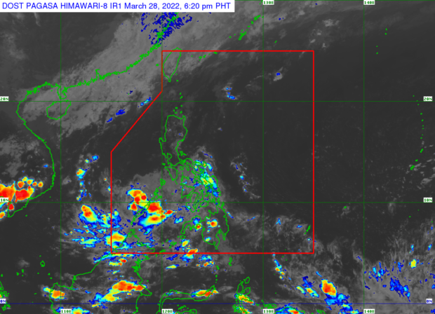
Source: DOST / Pagasa
MANILA, Philippines — The low pressure area (LPA) spotted over the Sulu sea will continue to bring rain to Palawan on Tuesday, as well as parts of the Zamboanga Peninsula, said the Philippine Atmospheric, Geophysical and Astronomical Services Administration (Pagasa).
The LPA was last spotted 100 kilometers north northwest of Zamboanga City, according to Pagasa, as it traverses over the Sulu Sea.
“Asahan pa rin po natin itong Palawan, ayan pong Puerto Princesa gayun din po ang Kalayaan Islands makakaranas pa rin ng mga pagulan na may pagkidlat pagkulog dulot pa rin ng LPA,” said Pagasa weather specialist Samuel Duran.
(Continue to expect Palawan, Puerto Princesa as well as the Kalayaan Islands to experience rains with lightning and thunderstorms caused by the LPA.)
“Samantala ang nalalabing bahagi naman ng Luzon ay makararanas ng mainit at maalinsangang panahon na may mga tiyansa ng thunderstorms pagdaating ng hapon at gabi,” he added.
(Meanwhile the rest of Luzon will experience hot and humid weather with chances of thunderstorms in the afternoon and evening.)
Meanwhile, apart from Zamboanga Peninsula which will continue to be affected by the LPA, Duran said the rest of Mindanao and Visayas will experience partly cloudy to cloudy skies with isolated rain showers due to the effects of the easterlies.
- Temperature range in key cities/areas according to Pagasa for Tuesday:
- Metro Manila: 24 to 34 degrees Celsius
- Baguio City: 16 to 25 degrees Celsius
- Laoag City: 24 to 32 degrees Celsius
- Tuguegarao: 24 to 34 degrees Celsius
- Legazpi City: 25 to 31 degrees Celsius
- Puerto Princesa City: 25 to 31 degrees Celsius
- Tagaytay: 22 to 31 degrees Celsius
- Kalayaan Islands: 26 to 31 degrees Celsius
- Iloilo City: 26 to 31 degrees Celsius
- Cebu: 26 to 31 degrees Celsius
- Tacloban City: 25 to 31 degrees Celsius
- Cagayan De Oro City: 24 to 30 degrees Celsius
- Zamboanga City: 25 to 31 degrees Celsius
- Davao City: 24 to 32 degrees Celsius
RELATED STORY:
Rain expected in Palawan, parts of Mindanao due to LPA; Fair weather elsewhere — Pagasa