Tropical depression outside PAR now a tropical storm; to enter PH on Dec 14
MANILA, Philippines — The tropical depression located outside the Philippine area of responsibility (PAR) intensified into a tropical storm on Monday, the Philippine Atmospheric, Geophysical and Astronomical Services Administration (Pagasa) said.
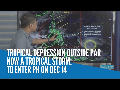
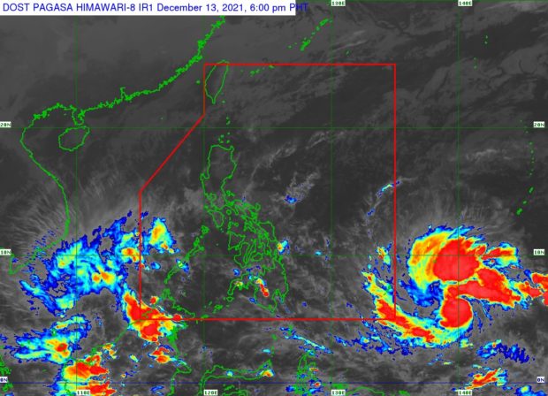
According to the state weather bureau’s 4 p.m., December 13, 2021, bulletin, the tropical storm with international name Rai was last spotted 1,645 kilometers (km) east of Mindanao packing wind speeds of up to 65 km per hour (kph) and gustiness of up to 80 kph.
Rai strengthened into a tropical storm at around 2 p.m. Monday, said Pagasa weather specialist Chris Perez, who added that within the next 24 hours or possibly by Tuesday night, the storm will enter the Philippine jurisdiction.
“Bukas within a 24 hour period, inaasahan natin na patuloy itong kikilos papalapit nga sa ating eastern boundary ng ating area of responsibility at bukas ng gabi posibleng pumasok na ito ng ating PAR,” Perez said.
Article continues after this advertisement(Tomorrow within a 24 hour period, we expect it to continue to move closer to the eastern boundary of our area of responsibility, and tomorrow night it may enter our PAR.)
Article continues after this advertisementOnce it enters PAR, Perez said, the storm will be named Odette and it would be the 15th tropical cyclone to enter the country this year.
Perez then warned that the tropical storm may further intensify into a typhoon before hitting land in the vicinity of the Caraga Region or Eastern Visayas by Thursday afternoon or evening.
Perez further warned the public of possible heavy rainfall while the storm hovers in the country. He said floods and landslides would be likely not just in the Visayas, but also in Southern Luzon and Mindanao.
“Hindi lamang Visayas area ang dapat maghanda, kundi ‘yung ilang bahagi ng Southern Luzon at ‘yung nakararaming bahagi ng Mindanao,” said Perez.
(Not only the Visayas area must prepare, but also some parts of Southern Luzon and most parts of Mindanao.)
Coastal inundation due to high waves near the coast and storm surges are also possible for low-lying localities near and along the path of the typhoon, according to Perez.
Pagasa likewise said the highest possible wind signal that may be hoisted during the typhoon’s expected onslaught would be Signal No. 3. It added that localities situated in the eastern portions of Visayas and Mindanao may be placed under Signal No. 1 as early as Tuesday afternoon or evening.
RELATED STORY
Pagasa: Tropical depression expected to enter PAR by Tuesday