Site of Baguio slide eyed as danger zone
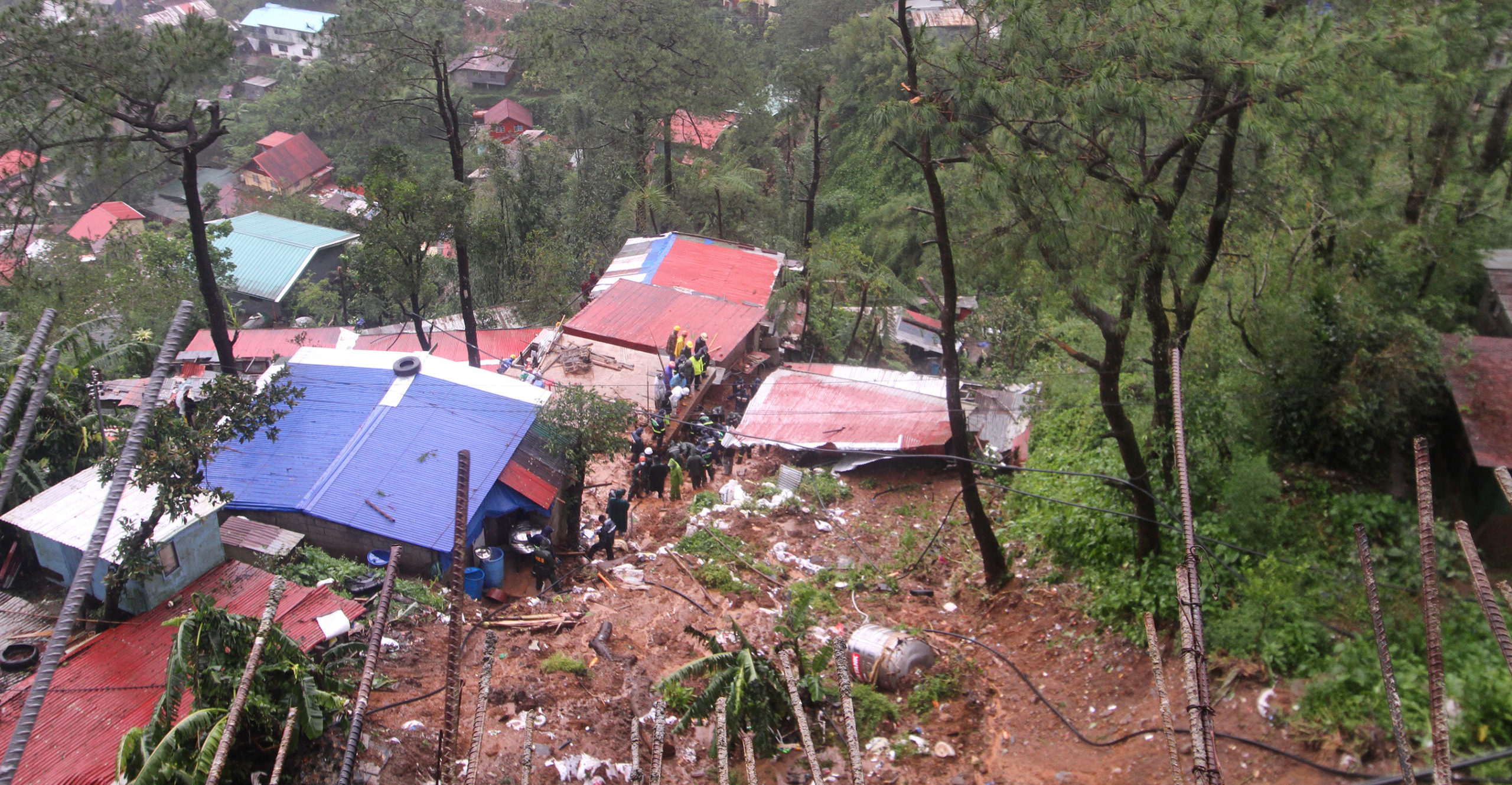
RACING AGAINST TIME A team of rescuers on Tuesday races against time to dig through the 3.05-meter-deep (10 feet) mud that buried a house at Dominican-Mirador village in Baguio City following a landslide triggered by heavy rain dumped by Severe Tropical Storm “Maring” on Monday night. —NEIL CLARK ONGCHANGCO/CONTRIBUTOR
BAGUIO CITY—The site of the deadly landslide that killed a grandfather and his two granddaughters on Monday is now being considered a danger zone by the local government.
City Administrator Bonifacio dela Peña said the unstable mountainside and the mud, estimated to be 3.05 meters (10 feet) deep, made rescue efforts dangerous, and would need to be examined because the area, where a number of people live, might no longer be habitable.
“The surface was too soft and rescuers were sinking in the mud,” said Dela Peña, a geodetic engineer.
Thick mudflow buried houses in Marosan Alley located below the old Diplomat Hotel in the village of Dominican-Mirador, killing Alfredo Ocampo and his granddaughters Talia, 12, and Judy, 4.
Heavy downpour
The heavy downpour was caused by Severe Tropical Storm “Maring” (international name: Kompasu), which dumped 625 millimeters of rainfall here on Monday and loosened the soil around the victims’ house, Dela Peña said.
A life sensor, which can detect sound from a depth of 12 m, was used during the rescue operation and for a while rescuers detected a weak heartbeat, Dela Peña said.
The area went silent hours later, forcing rescuers to blast the area with water until volunteers could dig up the persons buried underneath.
Dela Peña said engineers could not reinforce the damaged mountain wall without a geological assessment.
Mayor Benjamin Magalong earlier said that the city government would need to establish policies that would strictly ban settlements in areas declared as danger zones.
Dela Peña said they would need to enforce a housing ban on areas declared as danger zones to avoid what happened in 2009 when a landslide at Little Kibungan community in nearby La Trinidad, Benguet, left 77 residents dead.
The area was later declared a hazard zone. But 12 years later, multistory structures sprang up in the same community after a relocation program meant for the original inhabitants got entangled in legal issues. Government engineers had built a retaining wall over the unstable slope in Little Kibungan where the landslide started.
At the landslide site in Baguio, it was not clear if it was listed among the residential districts within geologically hazardous areas based on high-density maps developed by the city planning and development office at the start of the year.
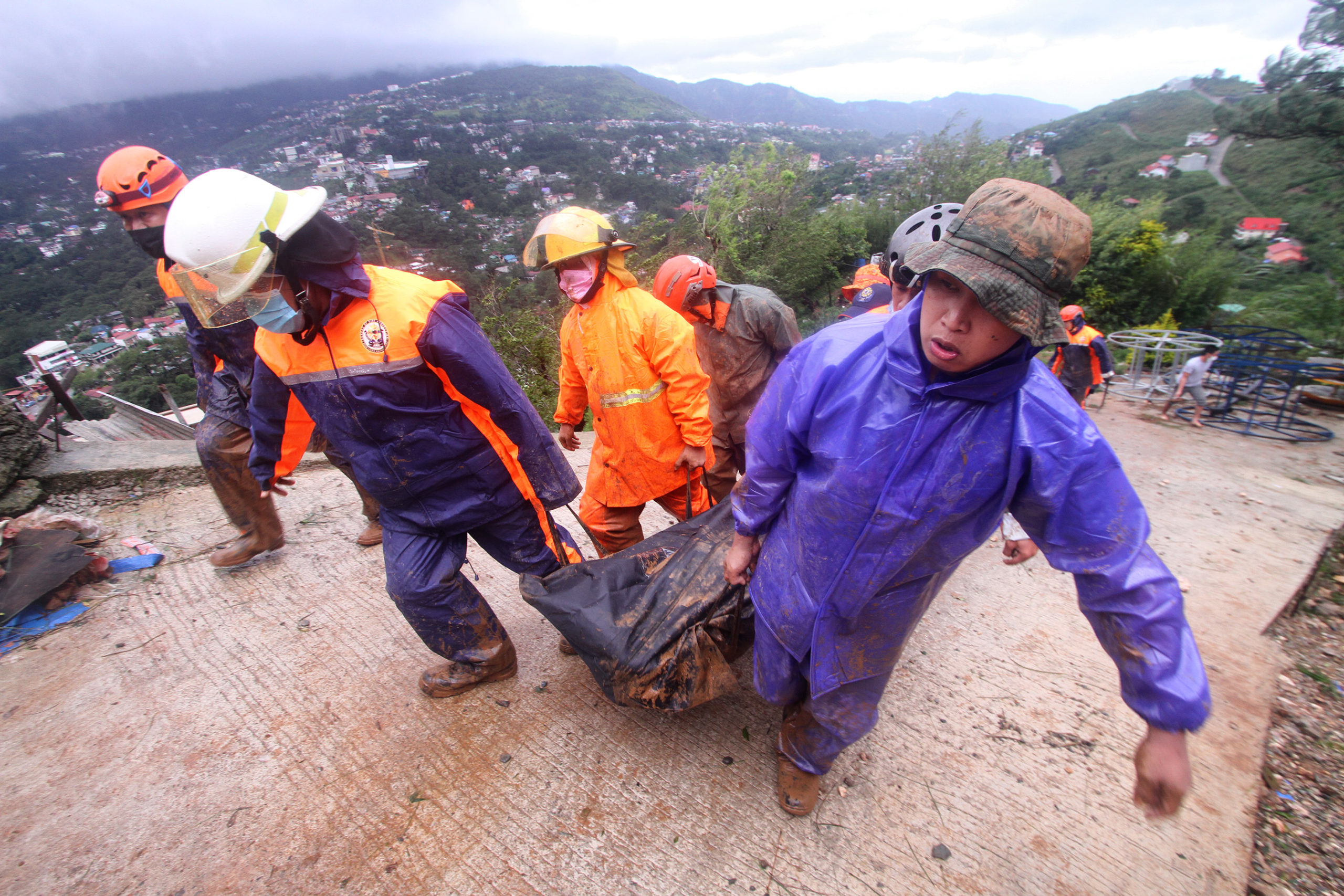
FATALITY Rescuers retrieve the body Alfredo Ocampo from the landslide area at Dominican-Mirador village in Baguio City on Tuesday morning. The bodies of his two granddaughters were recovered the following day. —NEIL CLARK ONGCHANGCO/CONTRIBUTOR
Vulnerable areas
These maps, which affixed structural data to geohazard maps provided by the Mines and Geosciences Bureau, identified Dominican Hill as among the 13.17 percent of the city territory that have “very high susceptibility” to landslides. About 65 percent of Baguio was also classified as highly vulnerable to erosion.
The maps were not meant to discourage construction in these areas, said city planning officer Donna Rillera-Tabangin, during a discussion with city managers early this year, but would help architects and engineers design buildings suited for the terrain and help investors determine where best to put up businesses.
The maps also identified flood-prone areas, spanning 81.99 hectares of Baguio, due in part to its natural gullies and catchment basins.
Government engineers are assessing structures along Baguio’s waterways to determine if these homes and buildings are obstructing the flow of rivers and creeks or are in danger of being close to these water bodies during the rainy season, Dela Peña said.
Flash floods hit city streets on Monday night, even with the recent installation of new drain pipes. Construction debris from a sidewalk project, pine needles and discarded face shields were discovered blocking inlets.
On Tuesday, Baguio’s 911 response system was activated by the government’s Emergency 911 Commission in the wake of the storm to allow Baguio workers to manage disasters.
The system is part of a Smart City automation network, which would be equipped with flood forecasting software, weather monitoring gear and access to landslide sensors to be deployed around Baguio, Magalong said.