Brace for TD Lannie’s heavy rain, Visayans warned
MANILA, Philippines — Residents of Western and Eastern Visayas and of the provinces of Mindoro, Marinduque, Romblon and Palawan should brace for moderate to heavy rain on Tuesday, brought by Tropical Depression Lannie.
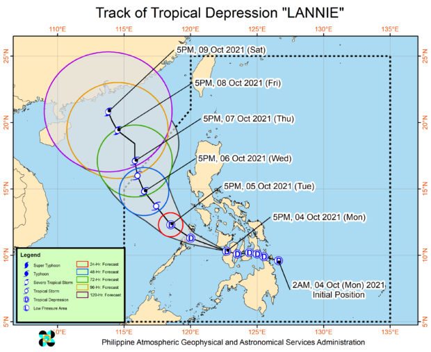
After making several landfalls throughout Monday, the cyclone is expected to emerge on Tuesday over the West Philippine Sea, the Philippine Atmospheric, Geophysical and Astronomical Services Administration (Pagasa) said.
It is expected to remain within the tropical depression category throughout the forecast period, although it may slightly gain strength once it is over the Sulu Sea or the West Philippine Sea.
Cloudy and rainy weather conditions are expected in Metro Manila and across the country on Tuesday, said Pagasa weather specialist Ariel Rojas, due to the widespread clouds brought by the cyclone.
Lannie, the 12th storm within the Philippine territory this year, first hit Bucas Grande Island in Surigao del Norte province at 4:30 a.m. on Monday, before making another landfall over Cagdianao in Dinagat Islands half an hour later.It made at least six other landfalls throughout the day, over Southern Leyte, Bohol, Cebu and Negros Oriental provinces.
Article continues after this advertisementOut of PH by Thursday
As of 4 p.m. on Monday, the cyclone was in the vicinity of Guihulngan City in Negros Oriental province. It blew winds of up to 45 kilometers per hour near the center, and gusts of up to 55 kph. It moved westward at 25 kph.
Article continues after this advertisementAs of Monday afternoon, Pagasa hoisted tropical cyclone wind signal No. 1 in the southern portions of Masbate, Romblon, Oriental Mindoro and Occidental Mindoro, the northern portion of Palawan including Calamian and Cuyo Islands, Capiz, Aklan, Antique, Iloilo, Guimaras, Negros Occidental, Cebu, Bohol and the northern and central portions of Negros Oriental.
Pagasa said Lannie was expected to move generally northwestward over the West Philippine Sea between late Tuesday through early Thursday.
By Tuesday evening or Wednesday early morning, it may intensify into a tropical storm.
It is forecast to leave the country’s area of responsibility on Thursday morning, and head toward southern mainland China.
