Jolina weakens into a tropical storm; Signal No. 2 still up in NCR, parts of Luzon
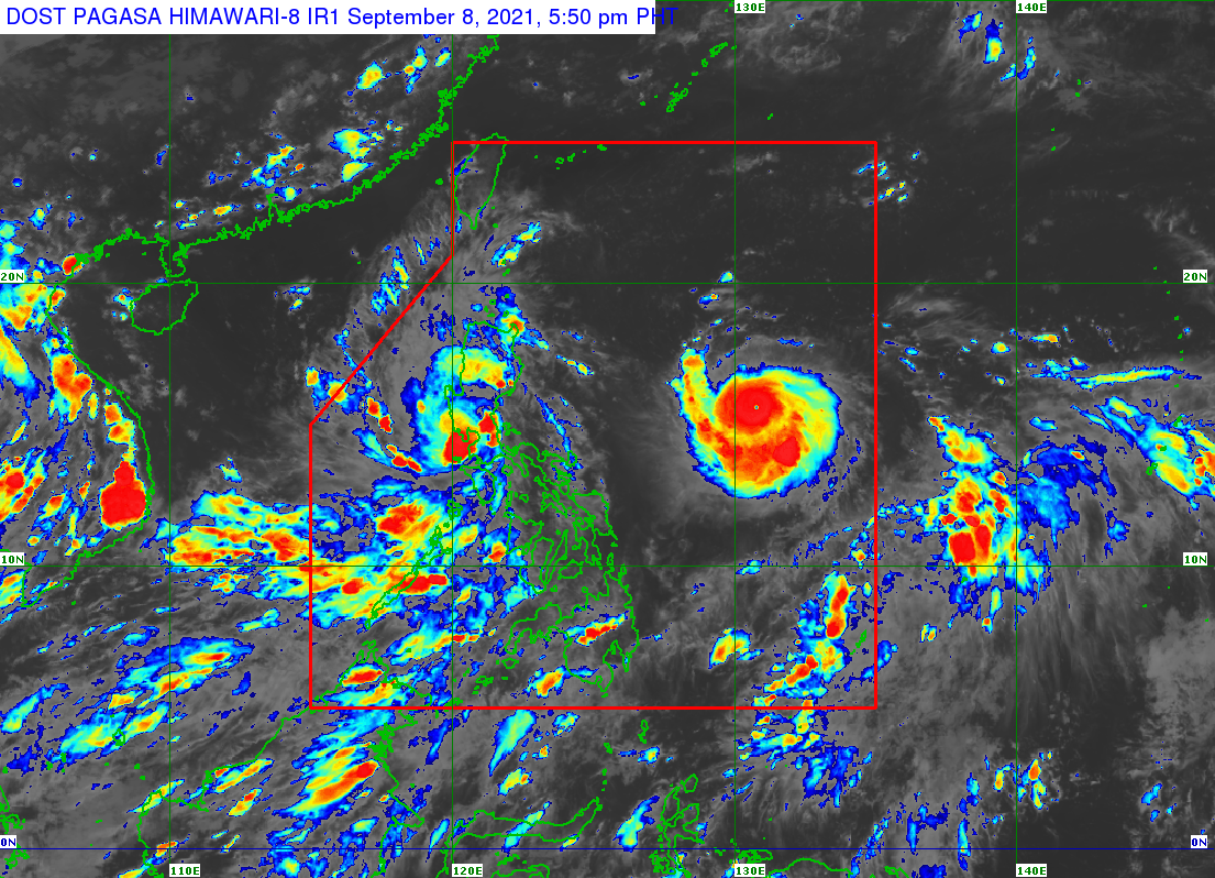
MANILA, Philippines — Severe Tropical Storm Jolina has weakened into a tropical storm on Wednesday afternoon as it crosses Manila Bay, the Philippine Atmospheric, Geophysical and Astronomical Services Administration (Pagasa) said.

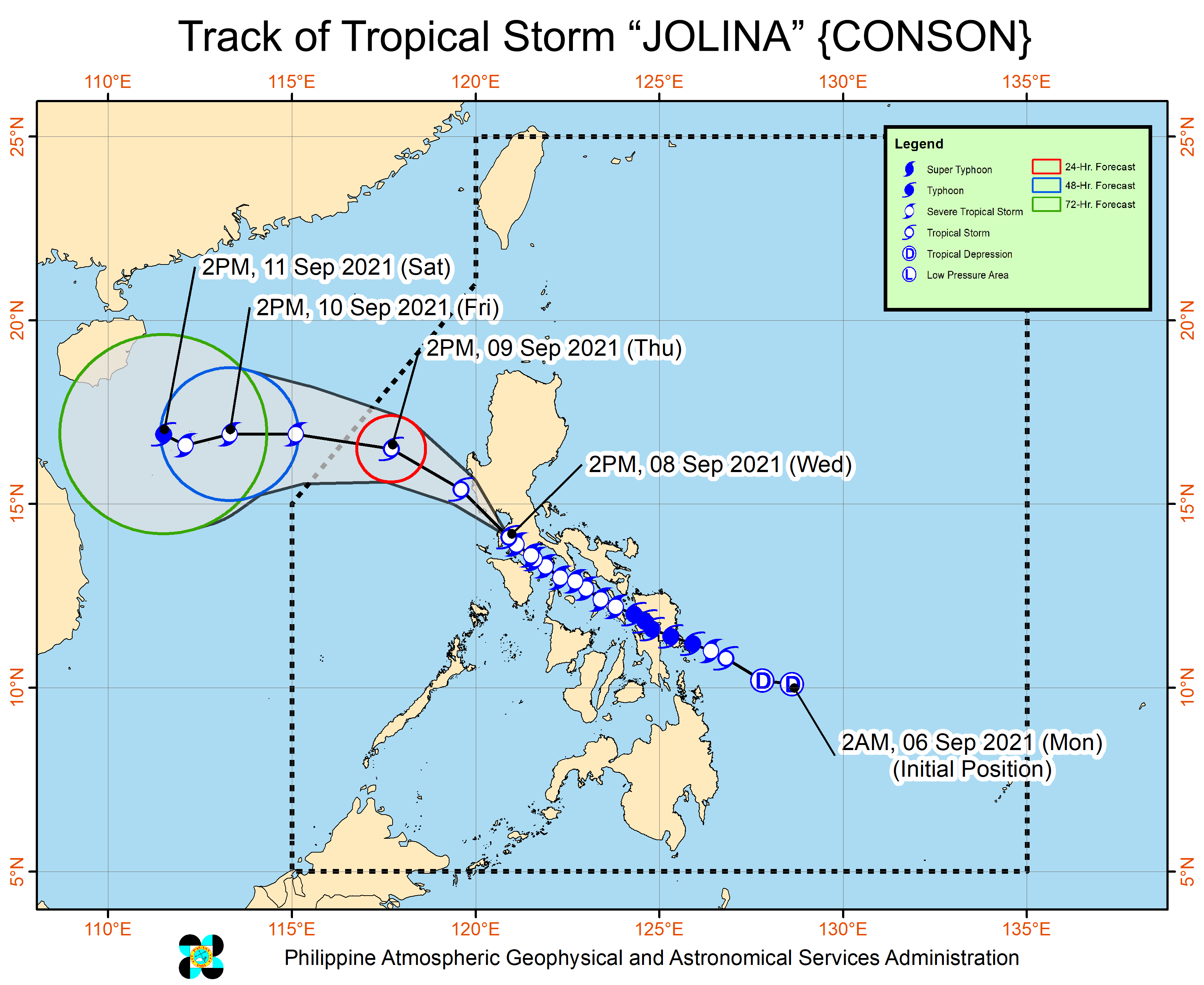
According to Pagasa, Jolina’s eye was last spotted 135 kilometers South of Sangley Pt., Cavite, moving northwestward at 10 kilometers per hour (kph).
It will continue to move generally northwestward over Manila Bay before making another landfall in the vicinity of the Bataan Peninsula this afternoon or evening.
The storm is packing maximum sustained winds of 85 kph near its center and gustiness of up to 115 kph.
Strong winds or higher extend outwards up to 170 km from the center.
Pagasa said heavy to intense rain will be experienced in Bataan, Cavite, Occidental Mindoro, and Oriental Mindoro over the next 24 hours.
Meanwhile, moderate to heavy with at times intense rains are also likely to be experienced in the rest of Central Luzon and Calabarzon, while light to moderate with at times heavy rains are expected in Metro Manila, Ilocos Region, Cordillera Administrative Region, and Cagayan Valley.
“Under these conditions, scattered to widespread flooding (including flash floods) and rain-induced landslides are highly likely especially in areas that are highly or very highly susceptible to these hazards,” said Pagasa in its latest cyclone bulletin.
The following areas are currently under Tropical Cyclone Warning System (TCWS) No. 2 where gale-force to storm-force winds are likely to be experienced, bringing generally light to moderate damage to structures and vegetation:
Luzon
The northern portion of Oriental Mindoro (Puerto Galera, San Teodoro, Baco, City of Calapan)
The northern portion of Occidental Mindoro (Abra de Ilog, Paluan, Mamburao, Santa Cruz) including Lubang Islands
The central portion of Quezon (Infanta, Real, Mauban, Sampaloc, Lucban, City of Tayabas, Lucena City, Sariaya, Candelaria, Dolores, Tiaong, San Antonio, Pagbilao)
Batangas
Cavite
Laguna
Rizal
Metro Manila
The Southern Portion of Bulacan (Pandi, Bulacan, Marilao, Calumpit, Norzagaray, Plaridel, Santa Maria, Balagtas, Bocaue, Bustos, City of Malolos, Angat, Obando, City of San Jose del Monte, Pulilan, City of Meycauayan, Hagonoy, Paombong, Guiguinto, San Rafael, Baliuag)
Pampanga
Bataan
Zambales
Tarlac
Meanwhile the following areas are under Signal No. 1, meaning strong winds with occasional gusts will be experienced in these areas which may result in very light damage to structures and vegetation:
Luzon
Marinduque
La Union
The Southern portion of Benguet (Sablan, Tublay, Bokod, La Trinidad, Baguio City, Itogon, Tuba, Kapangan, Atok)
The Southern portion of Nueva Vizcaya (Alfonso Castaneda, Dupax del Norte, Dupax del Sur, Aritao, Santa Fe, Kayapa)
The southern portion of Aurora (Baler, Maria Aurora, San Luis, Dingalan)
Pangasinan
Nueva Ecija
The rest of Bulacan
The northern and southern portions of Quezon (Padre Burgos, Agdangan, Unisan, Gumaca, Atimonan, Plaridel, Pitogo, Macalelon, Quezon, Alabat, Perez, General Nakar) including Polillo Islands
The central portion of Oriental Mindoro (Naujan, Victoria, Socorro, Pola, Pinamalayan, Gloria, Bansud)
The central portion of Occidental Mindoro (Sablayan)
According to Pagasa, Jolina is forecast to exit the Philippine Area of Responsibility on Thursday evening or Friday early morning.