Jolina now a typhoon: Signal No. 3 up in parts of Samar, No.2 in parts of Luzon
MANILA, Philippines — Jolina quickly intensified into a typhoon on Monday night, wreaking havoc in Eastern Visayas, the Philippine Atmospheric, Geophysical and Astronomical Services Administration (Pagasa) said Monday.
The eye of the typhoon was located in the vicinity of Llorente, Eastern Samar, as of 10:00 p.m and was moving northwestward at 20 kph.
It had maximum sustained winds of 120 kph near the center and a gustiness of up to 165 kph. Its strong winds extended up to 180 km from its center.
Jolina may bring heavy to intense with at times torrential rains over Samar, Eastern Samar, Northern Samar, and Sorsogon in the next 24 hours.
Moderate to heavy with at times intense rains are also likely over the rest of Eastern Visayas and the rest of the Bicol Region.
“Under these conditions, scattered to widespread flooding (including flash floods) and rain-induced landslides are possible especially in areas that are highly or very highly susceptible to these hazards,” Pagasa warned.
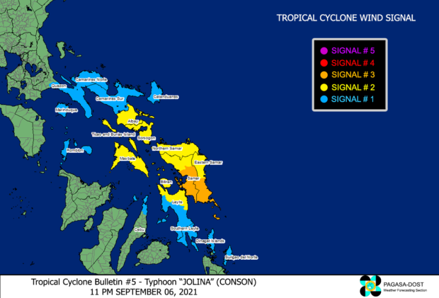
Tropical Cyclone Wind Signal No. 3 is currently up in the following areas:
- the southern portion of Eastern Samar: Guiuan, Mercedes, Salcedo, Hernani, General Macarthur, Quinapondan, Giporlos, Balangiga, Llorente, Balangkayan, Maydolong, City of Borongan, Lawaan
- the southern portion of Samar: Calbiga, San Sebastian, Hinabangan, Motiong, Jiabong, Catbalogan, Zumarraga, Daram, Villareal, Talalora, Pinabacdao, Santa Rita, Basey, Marabut, Paranas
Destructive typhoon-force winds should be expected within any of those areas as well as generally moderate to heavy damage to structures and vegetation.
The following areas are under Signal No. 2:
Luzon
- Albay
- Sorsogon
- Masbate including Ticao and Burias Islands
Visayas
- Northern Samar
- rest of Samar
- rest of Eastern Samar
- Biliran
- northern portion of Leyte : Calubian, San Isidro, Tabango, Leyte, Capoocan, Kananga, Jaro, Pastrana, Dagami, Tabontabon, Dulag, Tolosa, Julita, Tanauan, Palo, Santa Fe, Alangalang, Carigara, Tunga, Barugo, San Miguel, Babatngon, Tacloban City
Gale-force to storm-force winds are likely to occur in those areas, bringing generally light to moderate damage to structures and vegetation.
The following areas are under Signal No. 1:
Luzon
- the southern portion of Quezon: Pagbilao, Padre Burgos, Atimonan, Agdangan, Plaridel, Unisan, Gumaca, Pitogo, Macalelon, General Luna, Mulanay, Catanauan, San Francisco, San Andres, San Narciso, Buenavista, Lopez, Guinayangan, Tagkawayan, Calauag, Quezon, Alabat, Perez
- Camarines Norte
- Camarines Sur
- Catanduanes
- Romblon
- Marinduque
Visayas
- the rest of Leyte
- Southern Leyte
- northern portion of Cebu: Borbon, San Remigio, Tabogon, City of Bogo, Medellin, Daanbantayan, Santa Fe) including Bantayan and Camotes Islands
Mindanao
- Dinagat Islands
- Siargao Islands
- Bucas Grande Islands
Strong winds with occasional gusts will be experienced in those areas which may result in very light damage to structures and vegetation.