Jolina intensifies into tropical storm; signal No. 2 up in parts of Samar
MANILA, Philippines — Tropical Depression Jolina has intensified into a tropical storm as it continues to move west northwest nearing landfall in Eastern Visayas, the Philippine Atmospheric, Geophysical and Astronomical Services Administration (Pagasa) said Monday.
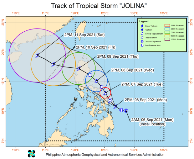
Jolina intensified into a tropical storm at 2 p.m. and is expected to slightly intensify as it moves over the Philippine Sea.
“Halos lumalapit na sa kalupaan ng Eastern Visayas ang sentro ng bagyong si Jolina,” said Pagasa senior weather specialist Chris Perez.
(The center of typhoon Jolina is almost approaching the landmass of Eastern Visayas.)
As of 4 p.m., Jolina was spotted 95 kilometers (kms) east of Guiuan, Eastern Samar, with maximum sustained winds of 75 kilometers per hour (kph) and gusts at 90 kph.
It continues to move west northwest at 20 kph.
Article continues after this advertisement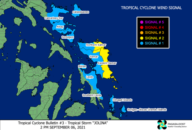
“‘Yung makapal na kaulapan ay nasasakop na ‘yung nakararaming bahagi ng Visayas, ilang bahagi ng Bicol at ilang bahagi ng Caraga Region,” said Perez.
(Its thick clouds have covered most parts of the Visayas, some parts of Bicol and some parts of the Caraga Region.)
“Bukod pa diyan ‘yung pinagibayong habagat nagdudulot din ng kaulapan, dito nga sa natitirang bahagi ng kabisayaan ilang bahagi ng Southern Luzon at natitirang bahagi ng Mindanao,” he added.
(Apart from that, the southwest monsoon will bring clouds here in the rest of the Visayas and some parts of southern Luzon and the rest of Mindanao.)
The storm is expected to reach its peak intensity of 85 kph by Wednesday, and will then weaken as it moves over the rugged terrain of the Northern-Central Luzon area, said Perez.
Tropical Cyclone Wind Signal (TCWS) No. 2 is currently up in the following areas:
- Eastern Samar
- Eastern Portion of Northern Samar
- Northeastern portion of Samar
Strong to gale-force winds are expected in these areas.
Meanwhile, the following areas are under TCWS No. 1, where strong winds with occasional gusts are expected:
- Biliran
- Eastern portion of Leyte
- Eastern portion of Southern Leyte
- Rest of Samar
- Rest of Northern Samar
- Dinagat Islands
- Siargao Islands
- Bucas Grande Islands
- Eastern portion of camarines sur
- Catanduanes
- Albay
- Sorsogon
According to Perez, Jolina is expected to track generally northwestward parallel to the east coast of the country until it makes landfall over the Northern-Central Luzon area by Thursday morning.
Afterwards, the tropical storm will move generally westward while traversing over the Northern- Central Luzon area and may re-emerge over the West Philippine Sea by Thursday evening.
It is forecasted to exit the Philippine Area of Responsibility by Friday.