Pagasa: More monsoon in parts of Luzon; cloudy skies over Metro Manila
MANILA, Philippines — Monsoon rain will persist in parts of northern and western Luzon while slightly cloudy to cloudy skies can be expected over the rest of the region, including Metro Manila, from Tuesday night through Wednesday, the state weather bureau said.
This, as the Philippine Atmospheric, Geophysical and Astronomical Services Administration (Pagasa) also noted in its latest weather bulletin that hot and sunny weather will likely prevail in Visayas and Mindanao even if scattered rain due to thunderstorms remains possible in these regions on Wednesday afternoon and night.
“Asahan pa rin po ‘yung monsoon rains sa bahagi ng (expect monsoon rains in parts of) Ilocos Region, Batanes, Babuyan group of islands, Abra, Apayao, Benguet, Zambales and Bataan,” said Pagasa weather specialist Joey Figuracion.
“Occasional rains ay aasahan pa rin sa (should still be expected in) Metro Manila, Tarlac, Pampanga, Bulacan, Cavite, Batangas, Rizal, Occidental mindoro, Oriental Mindoro, Palawan, Cordillera Administrative Region, and Cagayan Valley,” he added.
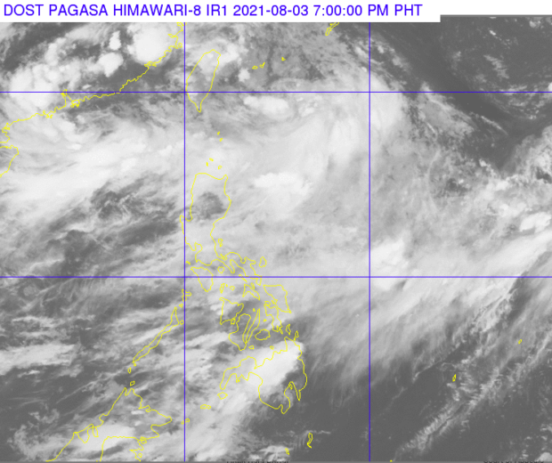
Article continues after this advertisementFiguracion also said that Pagasa is monitoring two low-pressure areas (LPA) and two tropical depressions.
Article continues after this advertisementOne LPA, he said, is inside the Philippine Area of Responsibility (PAR) and last spotted 580 kilometers (km) northeast of Itbayat, Batanes. It is expected to become a storm in the next 48 hours, but should also leave PAR by then, he noted.
The other LPA, he added, is located east of northern Luzon although outside PAR. It is continuing to move farther away, he also said.
On the other hand, the two tropical depressions are also outside PAR. However, Pagasa pointed out, the two tropical depressions are part of the “monsoon draft.”
“Kaya naman asahan pa rin ‘yung mga paguulan sa mga darating na araw, lalong-lalo na sa may Luzon,” Figuracion said.
(That is why we should expect rains in the coming days, especially in Luzon.)
The first tropical depression located near Hong Kong was last spotted 850 km west of extreme northern Luzon, while the second tropical depression was last spotted 3025 km east-northeast of extreme northern Luzon.
Meanwhile, the forecast temperature range in key cities/areas are as follows:
- Metro Manila: 26 to 31 degrees Celsius
- Baguio City: 17 to 20 degrees Celsius
- Laoag City: 26 to 30 degrees Celsius
- Tuguegarao: 25 to 34 degrees Celsius
- Legazpi City: 28 to 32 degrees Celsius
- Puerto Princesa City: 26 to 32 degrees Celsius
- Tagaytay: 23 to 29 degrees Celsius
- Kalayaan Islands: 28 to 31 degrees Celsius
- Iloilo City: 26 to 32 degrees Celsius
- Cebu: 26 to 33 degrees Celsius
- Tacloban City: 26 to 35 degrees Celsius
- Cagayan De Oro City: 23 to 35 degrees Celsius
- Zamboanga City: 26 to 33 degrees Celsius
- Davao City: 27 to 33 degrees Celsius
Pagasa said gale warning remains over the northern and western seaboards of Luzon. Thus, Figuracion warned fisherfolks with small boats against sailing out to the sea.
“Delikado sa ating mga kababayan ang maglayag lalong-lalo na sa mga gumagamit ng maliliit na sasakyang pandagat,” said Figuracion.
(It is dangerous for our fellowmen to set sail especially for those who use small marine vessels.)