Fabian nearly out of PAR, but still intensifies habagat — Pagasa
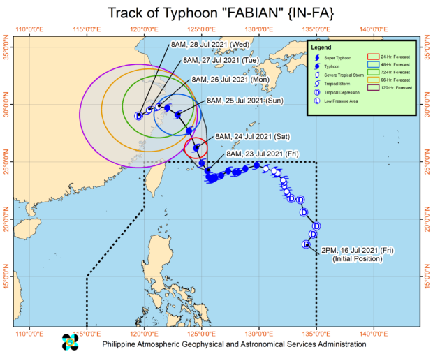
Track of Typhoon Fabian. Image from Pagasa / DOST
MANILA, Philippines — Despite Typhoon Fabian heading its way out of the Philippine area of responsibility (PAR), state meteorologists noted that it still intensifies the southwest monsoon or habagat, bringing rains in various parts of Luzon and Visayas.
The latest weather bulletin from the Philippine Atmospheric, Geophysical and Astronomical Services Administration (Pagasa) on Friday afternoon showed Fabian hovering around 540 kilometers northeast of Itbayat, Batanes.
It was able to maintain its strength, packing maximum sustained winds of 150 kilometers per hour (kph) near the center, and gustiness of up to 185 kph. Fabian is moving west northwest at a speed of 10 kph, which means it is now moving faster than it did on Thursday.
“Nalalapit nang makalabas ng PAR itong si Bagyong Fabian, nakikita natin sa ating satellite animation itong pag-cross nitong eyewall nito sa northern boundary ng PAR,” weather specialist Ariel Rojas said.
(Typhoon Fabian is nearly out of the PAR, as we have seen through our satellite animation that the eyewall has crossed the northern boundary of the PAR.)
Article continues after this advertisement“Patuloy pa rin pong hinihila at pinapalakas nitong si Fabian itong ating southwest monsoon or habagat, na nagdudulot pa rin ng pag-ulan sa malaking bahagi ng kanlurang Luzon at Visayas,” he added.
Article continues after this advertisement(However, Fabian still pulls and intensifies the southwest monsoon or habagat, which then brings rains over a huge part of Luzon and Visayas’ western sections.)
As of now, Tropical Cyclone Wind Signal No. 1 is still raised over the province of Batanes. Strong winds may still affect the area in the next 24 to 36 hours.
Rainfall warnings were also raised in Occidental Mindoro and Oriental Mindoro (Orange Warning) and in Zambales, Bataan, Marinduque, Romblon, Calamian Islands, portions of La Union, Benguet, Pangasinan, Tarlac, and Pampanga (Yellow).
Pagasa also announced that weather specialists are monitoring another tropical depression outside PAR, still 2,770 kilometers east northeast of extreme Northern Luzon. It is not expected, however, to affect the country as its current path veers towards the central part of Japan.
Gale warnings are still in place over the entire seaboards of Luzon, Western Visayas, and Eastern Visayas due to the monsoon rains and winds. This means sea travel would be risky, especially for small boats.
RELATED STORY:
Fabian maintains strength; monsoon rains to persist over parts of Luzon