Bising keeps strength, may exit PAR on Sunday as severe tropical storm
MANILA, Philippines — Typhoon Bising has maintained its strength and may gradually weaken as it possibly leaves the Philippines by Sunday as a severe tropical storm.

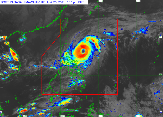
Based on the state weather services Tuesday afternoon bulletin, Bising was last spotted 475 kilometers east of Baler, Aurora, packing maximum sustained winds of 175 kilometers per hour (kph) near the center and gustiness of up to 215 kph.
but state meteorologists said that it may gradually weaken as it slowly exits the Philippine area of responsibility (PAR).
The Philippine Atmospheric, Geophysical and Astronomical Services Administration (Pagasa) said the typhoon was still moving north-northwest at a slow pace and likely be at 315 kilometers east of Tuguegarao City in Cagayan by Wednesday afternoon.
The closest point at which Bising will be to land is around 290 kilometers east of Calayan, Cagayan on Thursday afternoon. After that, the typhoon may start recurving to the east, towards the Pacific Ocean, according to Pagasa.
It is then predicted to exit the Philippine area of responsibility by Sunday afternoon, probably as a severe tropical storm, it added.
For now, however, certain areas in Luzon remain under Tropical Cyclone Wind Signal No. 2, which means that wind speeds of 61 kph to 120 kph may be felt in these areas within the next 24 hours:
- eastern portion of Cagayan (Santa Ana, Gonzaga, Baggao, Gattaran, Lal-Lo, Peñablanca, Santa Teresita, Buguey, Camalaniugan, Aparri)
- eastern portion of Isabela (San Pablo, Maconacon, Divilacan, Ilagan, Palanan, San Mariano, Dinapigue)
- northern portion of Aurora (Dilasag)
- Catanduanes
The following areas in Luzon, meanwhile, are under Signal No. 1:
- Batanes
- the rest of Cagayan, including Babuyan Islands
- the rest of Isabela
- Quirino
- Apayao
- Kalinga
- eastern portion of Mountain Province (Barlig, Natonin, Paracelis, Sadanga, Bontoc)
- eastern portion of Ifugao (Banaue, Lagawe, Mayoyao, Aguinaldo, Alfonso Lista, Hingyon)
- northeastern portion of Nueva Vizcaya (Diadi)
- central portion of Aurora (Casiguran, Dinalungan, Dipaculao, Baler)
- eastern portion of Quezon (Calauag, Guinayangan, Tagkawayan) including Polillo Islands
- Camarines Norte
- Camarines Sur
Pagasa said sea travel is not allowed in waters adjacent to towns under a tropical cyclone wind signal. Also, a gale warning remains over the waters of Ilocos Norte, Cagayan, including the Babuyan Islands, and the northern and eastern waters of Eastern Visayas.
RELATED STORY
20 crew missing after vessel runs aground amid Typhoon Bising
KGA