Signal No. 1 up in 14 areas due to typhoon Bising
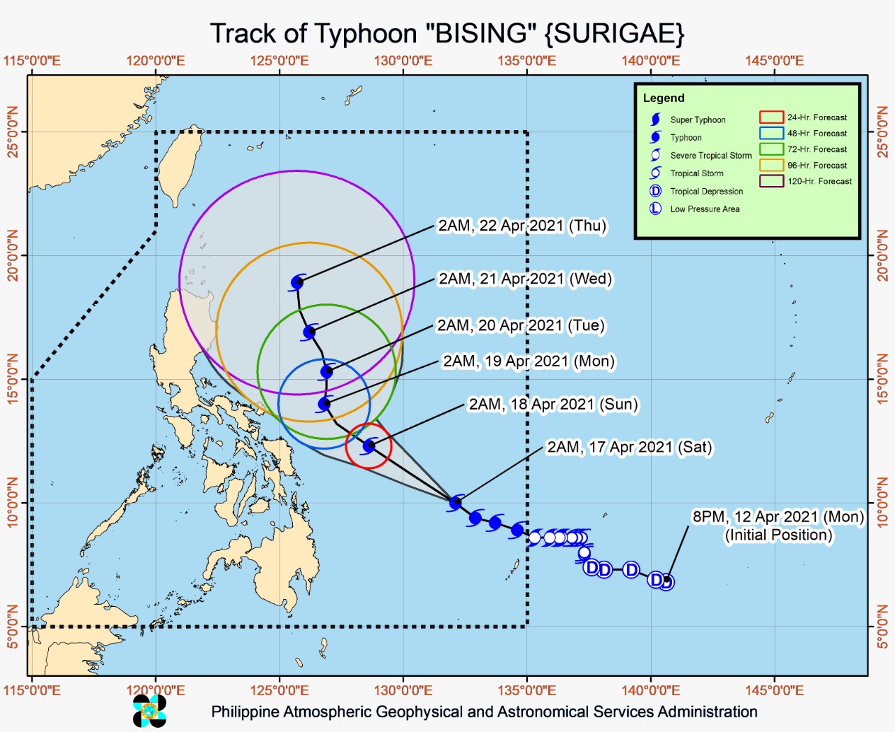
Latest track of typhoon Bising. Image from Pagasa
MANILA, Philippines — Tropical cyclone wind signal (TCWS) No. 1 is raised over 14 areas as of Saturday morning as typhoon Bising continues to rapidly intensify while moving west-northwestward over the Philippine Sea.
The center of the eye of the typhoon was last located 705 kilometers east of Surigao City, Surigao del Norte or 775 km east of Maasin City, Southern Leyte, according to the Philippine Atmospheric, Geophysical and Astronomical Services Administration (Pagasa).
The weather disturbance is moving west-northwestward at 20 kilometers per hour and has maximum sustained winds of 175 kilometers per hour near the center and gustiness of up to 215 kph.
Based on Pagasa’s severe weather bulletin issued at 5 a.m., TCWS No. 1 is raised in the following areas:
Luzon
- Central and eastern portions of Sorsogon (Castilla, Magallanes, Matnog, Juban, Irosin, Bulan, Santa Magdalena, Bulusan, Barcelona, Casiguran, Gubat, Prieto Diaz, Sorsogon City)
- eastern portion of Albay (Manito, Legazpi City, Santo Domingo, Malilipot, Bacacay, Tabaco City, Rapu-Rapu, Malinaw, Tiwi)
- eastern portion of Camarines Sur (Presentacion, Caramoan, Garchitorena) Catanduanes
Visayas
- Northern Samar
- Samar
- Eastern Samar
- Biliran
- Leyte
- Southern Leyte
- Camotes Islands
Mindanao
- Dinagat Islands
- Surigao del Norte (including Siargao and Bucas Grande Islands)
- Surigao del Sur
Pagasa said winds of 30 to 60 kph may be expected in at least 36 hours or intermittent rains may be expected within 36 hours in areas under TCWS No. 1.
“Tropical cyclone winds of at least strong breeze to near gale in strength extend outward up to 550 km from the center of the typhoon. Destructive typhoon-force winds extend outward up to 50 km from the center of the typhoon,” Pagasa added.
TCWS No. 1 may also be hoisted over the eastern portion of Masbate, northern portion of Cebu, and other localities of Albay and Camarines Sur in the next weather bulletin, according to the weather agency.
Pagasa said “Bising” will move generally west-northwestward or northwestward over the Philippine Sea until Sunday afternoon or evening.
“Afterwards, the typhoon will slow down and move northward or north-northeastward until Tuesday early morning before moving north-northwestward over the Philippine Sea east of Northern and Central Luzon,” the weather bureau added.
Pagasa noted that “Bising” has rapidly intensified over the past 24 hours due to favorable atmospheric and oceanic conditions. It is forecast to further intensify and reach its peak intensity at 195 to 205 kph on Sunday.