
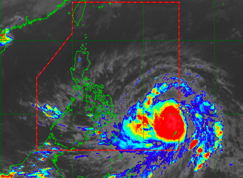
Typhoon Bising’s forecast track is closer to land than originally predicted. Satellite image/Himawari IR1 via Pagasa
MANILA, Philippines — Typhoon Bising’s latest forecast track on Friday showed that it would move closer to the country’s landmass, with state meteorologists not completely ruling out a landfall scenario in the coming days.
Latest updates from the Philippine Atmospheric, Geophysical and Astronomical Services Administration (Pagasa) showed Bising (international name Surigae) was last spotted 895 kilometers east of Surigao City in Surigao del Norte.
Despite Bising’s apparent westward progression of about 15 kilometers per hour (kph), Pagasa pointed out that its precise path relies in part on the interaction with a high-pressure area (HPA) north of it.
As the HPA ridge prevents Bising from moving immediately north, it also slows down the typhoon.
“May kabagalan nang bahagya itong bagyo dahil nga dito, makikita natin itong clear part na ‘to, ito ‘yong ridge of a high pressure area na nakakapigil para kumilos ng mabilis itong ating bagyong si Bising,” weather specialist Raymond Ordinario said.
(A ridge in the blank spot above encircles Typhoon Bising, preventing it from moving rapidly.)
“Ito nga ‘yong minomonitor nating in the coming days, dahil ito ang magdidikta kung paano kikilos itong bagyong Bising, dahil nga ito ‘yong main factor na nakaka-contribute dito sa movement ng bagyo,” he added.
(We will be monitoring this in the upcoming days because it would greatly affect Bising’s movement, as it plays a significant role in how the typhoon will move.)
Pagasa said that Bising is expected to move northeast, and it may be around 480 kilometers east of Guiuan, Eastern Samar. By Sunday afternoon, it will have moved around 295 kilometers east of Catarman, Northern Samar.
It would be at its closest to land on Monday, where it would be just 285 kilometers east of Virac, Catanduanes. But from there, Pagasa believes that it would start recurving back to the Pacific Ocean moving west as it would be around 620 kilometers east northeast of Infanta, Quezon.
However, parts of Northern Samar and islands near Catanduanes and Sorsogon remain in Pagasa’s cone of uncertainty, which means there is still a chance Bising will hit these areas.
In terms of strength, Bising is now packing a 130-kph sustained wind and gustiness up to 160-kph.
While no gale warnings have been issued even with the storm inside the Philippine area of responsibility, Pagasa said that the sea conditions over the whole eastern seaboard would be moderate to rough while the rest of the country will have a slight to moderate condition.