TS Auring slows down; More areas under Signal No. 2
MANILA, Philippines — More areas in the Visayas and Mindanao were placed under Tropical Cyclone Wind Signal (TCWS) No. 2 even as Tropical Storm Auring (international name: Dujuan) slowed down its approach to land, the state weather bureau said Sunday.
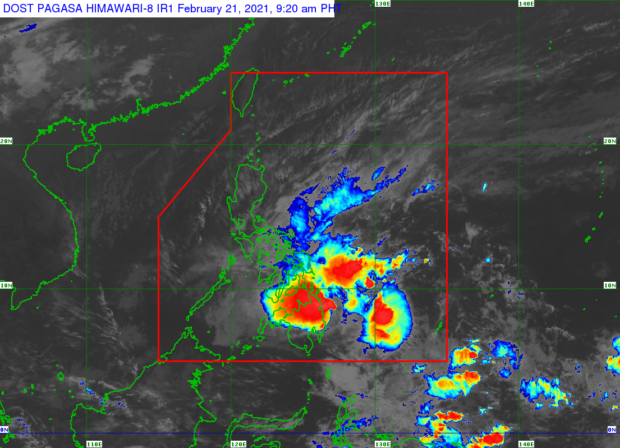
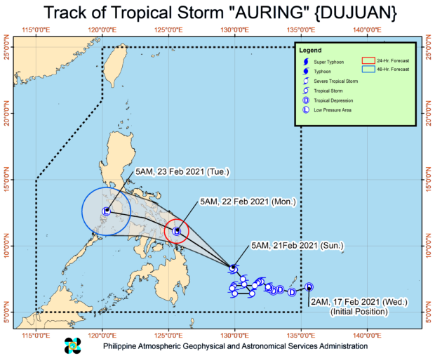
In its 8 a.m. severe weather bulletin, the Philippine Atmospheric, Geophysical and Astronomical Services Administration (Pagasa) said that Auring was last spotted at 370 kilometers east of Hinatuan, Surigao del Sur.
Auring is packing maximum sustained winds of 65 kilometers per hour (kph) near the center, and gustiness of up to 80 kph while moving west-northwest at 10 kph from 15 kph a few hours earlier.
Signal No. 2
TCWS No. 2 is hoisted over the following areas:
Visayas
– Central and southern portions of Eastern Samar (Sulat, Taft, San Julian, Borongan City, Maydolong, Balangkayan, Balangiga, Lawaan, Llorente, Hernani, General Macarthur, Quinapondan, Giporlos, Salcedo, Mercedes, Guiuan)
Mindanao
–Dinagat Islands
-Surigao del Norte including Siargao and Bucas Grande Islands
Signal No. 1
TCWS No. 1 , meantime, is up over the following areas:
Luzon
–Sorsogon
-Masbate including Ticao and Burias Islands
-Albay
-Catanduanes
-eastern portion of Camarines Sur (Caramoan, Presentacion, Sagnay, Buhi, Iriga City, Nabua, Bato, Balatan)
Visayas
–Northern Samar
-the rest of Eastern Samar
-Samar
-Biliran
-Leyte
-Southern Leyte
-Cebu
-Bohol
-Siquijor
-Negros Oriental
-northern and central portions of Negros Occidental (Kabankalan City, Himamaylan City, Binalbagan, Isabela, Moises Padilla, Hinigaran, La Castellana, Pontevedra, San Enrique, La Carlota City, Pulupandan, Valladolid, Bago City, Murcia, Bacolod City, Talisay City, Silay City, Enrique B. Magalona, Victorias City, Manapla, Cadiz City, Sagay City, Escalante City, Toboso, Calatrava, San Carlos City, Salvador Benedicto)
-eastern portion of Iloilo (San Rafael, Barotac Viejo, Lemery, Ajuy, Sara, Concepcion, San Dionisio, Batad, Estancia, Balasan, Carles)
-eastern portion of Capiz (Roxas City, Panitan, Ma-Ayon, Cuartero, Dumarao, Panay, Pontevedra, President Roxas, Pilar)
Mindanao
–Surigao del Sur
-Agusan del Norte
-Agusan del Sur
-Davao Oriental
-Davao de Oro
-Davao del Norte
-Davao City
-Camiguin
-Misamis Oriental
-Bukidnon
Landfall forecast
Based on Pagasa’s latest data, Auring is forecast to “continue moving generally west-northwestward to northwestward in the next 48 hours, with short-term erratic movement still likely prior to landfall.”
Auring may initially make landfall over the Dinagat Islands-Eastern Samar (southern portion including Homonhon Island)-Leyte area between Sunday night and Monday morning, Pagasa added.
State meteorologists also forecast that Auring will weaken to a tropical depression before it makes landfall “due to persistent high vertical wind shear associated with the surge of the northeast monsoon.”
“However, the possibility that the storm will maintain its strength until landfall is not yet ruled out,” Pagasa added.
Brace for heavy rains
Auring is expected to bring moderate to heavy rains with at times intense rains over Dinagat Islands, Surigao del Norte, and Surigao del Sur. Moderate to heavy rains over Eastern Visayas, Misamis Oriental, Bukidnon, Camiguin, and the rest of Caraga.
Meanwhile, light to moderate with at times heavy rains over Bicol Region, Mimaropa (Mindoro, Marinduque, Romblon, Palawan) Zamboanga Peninsula, Quezon, the northern portion of Davao Oriental, Davao de Oro, and the rest of Visayas and Northern Mindanao.

