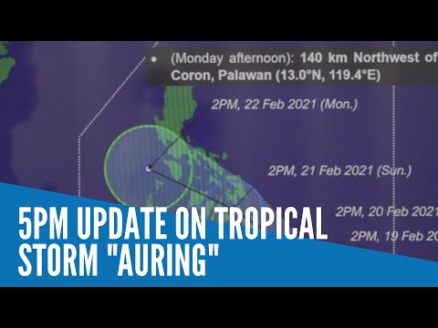
MANILA, Philippines — Tropical Storm Auring slightly weakened but state meteorologists said that it can re-intensify into a severe tropical storm as it stays over waters and before making landfall over the northeastern tip of Mindanao on Sunday morning.
Latest updates from Philippine Atmospheric, Geophysical, and Astronomical Services Administration (Pagasa) on Friday afternoon showed that Auring is still off-shore, at a distance of 415 kilometers east southeast of Hinatuan in Surigao del Sur.
Pagasa said that Auring now has maximum sustained winds of 85 kilometers per hour (kph) near the center and gustiness of up to 105 kph.
While it slightly weakened, its prolonged stay over waters is still expected to increase its strength and turn it into a severe tropical storm. However, a typhoon scenario remains less likely as Pagasa expects terrain and dry winds from the northeast monsoon to interact with the cyclone.
As of now, Tropical Cyclone Wind Signal No. 1 is raised in the following areas:
Dinagat Islands
Surigao del Norte
Surigao del Sur
Agusan del Norte
Agusan del Sur
Davao Oriental
Davao de Oro
Davao del Norte
Davao City
Camiguin
western portion of Misamis Oriental (Balingasag, Binuangan, Claveria, Gingoog City, Jasaan, Kinoguitan, Magsaysay, Medina, Salay, Sugbongcogon, Tagaloan, Talisayan, and Villanueva)
Southern Leyte
southern portion of Eastern Samar (Guiuan including Homonhon Island)
Pagasa clarified that some areas under Signal No. 1 may have yet to experience the strong winds and rains brought by Auring, as its trough only touches the eastern seaboards of Mindanao as of now.
“Bagamat may nakataas po tayong Warning Signal No. 1, hindi ibig sabihin ay agad-agad na may matitinding pag-ulan at pagbugso ng hangin. Actually, ‘yong mga areas na ito, ngayong gabi, ay makakaranas pa rin ng maulap na kalangitan, kalat-kalat na pag-ulan, at pagkidlat at pagkulog,” senior weather specialist Chris Perez said.
(Although we have raised Wind Warning Signal No. 1, it does not mean that these areas would immediately feel the effects of Auring, like strong rains and wind surges. Actually, these areas would still experience cloudy skies and occasional rains, thunderstorms, and lightning strikes by night.)
“Pero habang lumalapit po ‘yong bagyo, asahan na within 12 to 24 hours ay makakaranas na po ng mga pag-ulan at paminsan-minsang pagbugso ng hangin ang mga nabanggit nating lalawigan, at posible na sa susunod pa nating weather bulletin ay dadami ang lugar na may warning signal, at posible meron din tayong mas mataas na warning signal,” he added.
(But as the storm approaches, we are expecting that within 12 to 24 hours, these areas and provinces will experience the onset of heavy rains and occasional bursts of wind. It is also possible that for the next weather bulletins, more areas would be placed under a wind warning signal, and that higher warning signals may be issued.)
Auring is still predicted to move slowly over waters, as it is expected to be around 290 kilometers east of Hinatuan by Saturday afternoon. But with its wide radius of 300 kilometers, Pagasa believes that it would already have an effect over Mindanao’s eastern provinces even at this distance.
It would then move quicker, making landfall by Sunday morning over Caraga Region, then move east of Cebu province by afternoon. On Monday afternoon, it is expected to hover between northern Palawan and western Mindoro, before exiting the landmass through the West Philippine Sea.
As of now, gale warnings are still in place over the entire seaboards of Luzon, Visayas, and Northern Mindanao — due to the combined effects of the northeast monsoon and Tropical Storm Auring. This means sailing is risky over these areas, while any form of sea travel is already suspended over areas under a wind signal warning.
