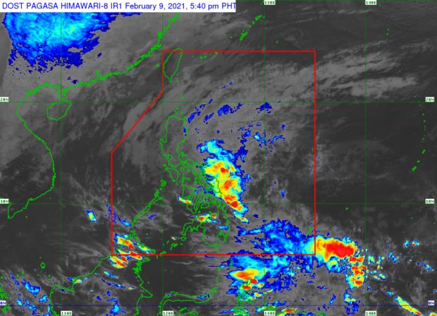

MANILA, Philippines — A new low-pressure area (LPA) east of Northern Samar and the tail end of a frontal system were causing precipitation over parts of Luzon and Visayas on Tuesday, state meteorologists said, adding such weather condition may even continue until Wednesday.
Based on the Philippine Atmospheric, Geophysical and Astronomical Services Administration’s (Pagasa) bulletin on Tuesday afternoon, the LPA was last spotted 125 kilometers east of Catarman town.
LPA’s presence, Pagasa said, means the warm winds or easterlies that contributed to its formation met winds brought by the northeast monsoon or amihan, creating a tail end of a frontal system.
Both LPA and cold front, it noted, would bring rains over Eastern Visayas, Bicol Region, Calabarzon, Oriental Mindoro, Marinduque, Romblon, Aurora from Tuesday night to Wednesday. However, Pagasa said the LPA is not expected to develop into a tropical cyclone.
For the rest of Luzon, including Metro Manila, the northeast monsoon will bring cold weather and light rain also from Tuesday night.
“Maulap pa rin na may kalat-kalat na pag-ulan bukas sa lalawigan ng Aurora, Quezon, Bicol Region, at ilang bahagi po ng Mimaropa dahil nga sa pinagsamang epekto ng tail end ng frontal system, at ng low pressure area,” senior weather specialist Chris Perez said.
(The areas of Aurora, Quezon, Bicol Region, and some parts of Mimaropa would continue to see cloudy weather with scattered rain showers due to the combined effects of the tail end of a frontal system and the low-pressure area.)
“Samantala ang amihan ay magdudulot pa rin ng maulap na kalangitan at mahinang pag-ulan dito sa may bandang Cagayan Valley, Cordillera Administrative Region, at ilang bahagi ng Central Luzon at maging dito sa may bahagi ng Metro Manila,” he added.
(Meanwhile, the northeast monsoon would still cause cloudy skies and light rain over areas in Cagayan Valley, Cordillera Administrative Region, and some parts of Central Luzon and even here in Metro Manila.)
Due to these systems, temperatures in Tuguegarao and Legazpi will remain low on Wednesday at 21 to 27 degrees Celsius and 23 to 29 degrees Celsius, respectively. Baguio will still be cold at 15 to 24 degrees Celsius; the same goes for Tagaytay at 21 to 28 degrees Celsius, and Metro Manila at 23 to 31 degrees Celsius.
Eastern Visayas will also experience rain while the rest of Visayas and Mindanao may have generally fair weather with possible isolated rain by Wednesday afternoon and night. Tacloban’s climate will be between 24 and 29 degrees Celsius, slightly colder than Iloilo and Cebu’s 24 to 31 degrees Celsius.
In Mindanao, Davao will be warm at 24 to 32 degrees Celsius, Zamboanga at 24 to 33 degrees Celsius, and Cagayan de Oro at around 23 to 31 degrees Celsius.
Meanwhile, a gale warning remains hoisted over the seaboards affected by the amihan, particularly western and northern waters of Ilocos Norte, Batanes, the northern and eastern coastlines of Cagayan Valley, including Babuyan Islands, and waters surrounding Quezon province and Bicol Region.
Fisherfolks were then advised not to go out to sea because of rough to very rough sea conditions.