LPA to enter PAR within 12 hours, says Pagasa
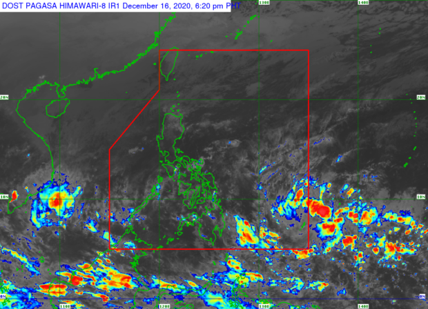
Pagasa satellite image
MANILA, Philippines — Cloud clusters east of the country have developed into a low-pressure area (LPA), which state meteorologists expect to enter the Philippine area of responsibility (PAR) in the next 12 hours.
However, weather forecasts from the Philippine Atmospheric, Geophysical and Astronomical Services Administration (Pagasa) on Wednesday afternoon showed that the LPA, located 1,025 kilometers east southeast of Mindanao, is not likely to develop into a tropical cyclone.
Still, Pagasa said, the LPA will bring rains over Mindanao, Visayas, and even the southern portions of Luzon, including the Bicol Region, starting Thursday up to the weekend.
On Tuesday, Pagasa’s climatology division predicted the formation of the LPA based on models that were created after cloud bands started appearing on the Pacific Ocean. However, Pagasa also noted that the chance of storms for the remaining of 2020 remains low.
But even before the LPA enters PAR, Pagasa said cloudy skies and rain would still be felt in various areas due to existing weather systems such as the northeast monsoon or amihan and the tail end of a frontal system.
Article continues after this advertisementFrom Wednesday night to Thursday morning, there will be light to moderate with at times heavy rains in Visayas, Bicol Region, Mimaropa, and Quezon province due to the frontal system, according to the state weather bureau.
Article continues after this advertisementEastern parts of Mindanao will be affected by the trough or the extension of the LPA, which means that cloudy weather with isolated thunderstorms would prevail in the next 12 hours, it said.
Northern Luzon and eastern parts of Central Luzon will experience light to moderate rains, while the northern part of Cagayan will see occasional heavy rains due to the amihan, which can cause floods in Cagayan Valley and possible landslides in the Cordillera Administrative Region, it also said.
Meanwhile, weather would slightly be colder in areas affected by the monsoon with Tuguegarao’s temperatures possibly falling to around 22 to 27 degrees Celsius as the climate in Laoag will be at 26 to 29 degrees Celsius, Baguio at 15 to 23 degrees Celsius, and Legazpi at 26 to 30 degrees Celsius.
Metro Manila will see partly cloudy to cloudy skies, as temperatures would also drop to as low as 23 degrees Celsius, Pagasa noted.
Some areas in Visayas and Mindanao may also experience cold weather due to the frontal system and the LPA’s trough. According to Pagasa, Tacloban may register temperatures of 24 to 30 degrees Celsius while Davao will have it between 23 and 31 degrees Celsius. Cebu’s weather will be at 26 to 31 degrees Celsius and Zamboanga at 25 to 34 degrees Celsius.
Gale warnings are still raised in Northern Luzon, particularly over the seaboards of Cagayan, Batanes, Babuyan Islands, and the whole Ilocos Region shoreline, Pagasa said. Sea conditions in these areas will be rough, the state weather bureau noted, as waves may reach heights of 2.8 meters to 4.5 meters.
Pagasa said that small boats are not allowed to sail in these areas as sea travel might be risky.