Rain showers in parts of Luzon, Visayas, Mindanao due to 2 LPAs — Pagasa
The Philippine Atmospheric, Geophysical and Astronomical Services Administration (Pagasa) is monitors]ing two low pressure areas within the Philippine area of responsibility and a tropical depression outside PAR on Monday, October 5, 2020. (Screenshot from Pagasa’s weather forecast
MANILA, Philippines — The southwest monsoon and two low pressure areas (LPAs) within the Philippine area of responsibility will bring cloudy skies with scattered rain showers and thunderstorms to the Visayas, Mimaropa (Mindoro, Marinduque, Romblon, Palawan) and Bicol regions, Quezon, Zamboanga Peninsula, Northern Mindanao, Bangsamoro Autonomous Region in Muslim Mindanao and Soccsksargen.
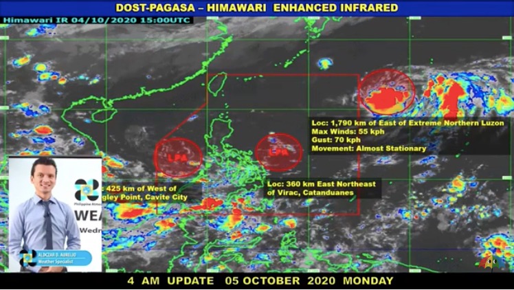
In its 4a.m. bulletin, the Philippine Atmospheric, Geophysical and Astronomical Services Administration (Pagasa) said one of the LPAs was last spotted 425 kilometers west of Sangley Point in Cavite.
Pagasa weather specialist Aldczar Aurelio said this LPA is forecast to move generally westward and may develop into a tropical depression within 24 to 48 hours outside PAR.
The other LPA was last spotted 360 kilometers east northeast of Virac, Catanduanes. Aurelio said it has a slim chance of developing into a tropical depression and may dissipate in the next 24 to 48 hours.
Meanwhile, the tropical depression earlier spotted by Pagasa outside PAR was last located 1,790 km east of extreme northern Luzon.
Article continues after this advertisementIt is almost stationary and has maximum sustained winds of 55 kilometers per hour near the center and gustiness of up to 70 kph.
Article continues after this advertisement“Inaasahan natin sa mga susunod na oras ay hindi aalis sa kinalalagyan itong tropical depression. Posibleng pumasok sa PAR itong bagyong ito at tatawagin nating Nika kapag pumasok sa PAR,” Aurelio said.
(In the coming hours, we don’t expect this LPA to move from its current position. It may enter PAR and will be locally known as named Nika.)
“Ang magiging forecast track nito ay lalapit ito sa northern part ng PAR at maaaring sandali lamang po siya sa loob ng PAR. Ang magiging pagkilos nito ay generally westward and then after days or hours ay magiging northwestward ang movement nito,” he added.
(On its forecast track, the tropical depression may move near the northern part of PAR and may enter stay inside PAR for a while. It will move generally westward and then after days or hours will turn northwestward.)
Forecast temperature range in key cities/areas:
Metro Manila: 25 to 33 degrees Celsius
Baguio City: 16 to 24 degrees Celsius
Laoag City: 24 to 34 degrees Celsius
Tuguegarao: 23 to 33 degrees Celsius
Legazpi City: 25 to 32 degrees Celsius
Puerto Princesa City: 26 to 32 degrees Celsius
Kalayaan Islands: 26 to 32 degrees Celsius
Iloilo City: 26 to 32 degrees Celsius
Cebu: 25 to 32 degrees Celsius
Tacloban City: 25 to 32 degrees Celsius
Cagayan De Oro City: 25 to 32 degrees Celsius
Zamboanga City: 24 to 33 degrees Celsius
Davao City: 25 to 33 degrees Celsius