Hot and humid weather to continue; no storm to affect PH – Pagasa
MANILA, Philippines — Hot and humid weather will carry on in the coming days as state meteorologists said Wednesday that the tropical cyclone spotted east of the country would have no direct effect on the Philippines’ climate at this time.
The Philippine Atmospheric, Geophysical and Astronomical Services Administration (Pagasa) said in its forecast issued on the afternoon of September 2 that Severe Tropical Storm “Haishen” located 2,025 kilometers east of Basco, Batanes, may enter the Philippine area of responsibility (PAR) by Friday or over the weekend.
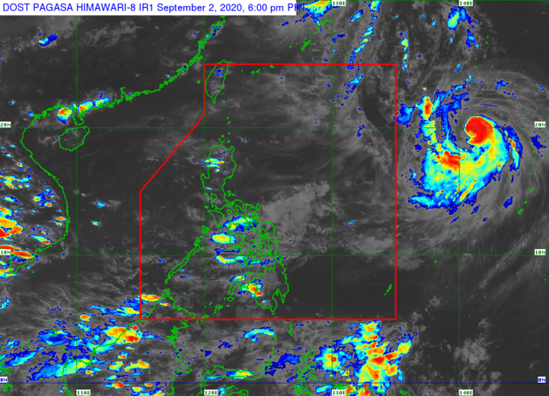
However, even if the storm intensifies in the days to come, it would have no direct effect on the country’s weather because it will only graze the northeastern corner of the PAR. Pagasa said that Haishen is seen to move towards the southwestern part of Japan and the southern tip of South Korea after it exits the country.
“Inaasahan natin na ito ay bahagyang kikilos pa-timog-kanluran, then pa-kanluran, and hilagang kanluran sa mga darating na araw. Kung ating mapapansin laos nandito na siya sa northeastern boundary lang ng PAR at hindi naman inaasahan na magla-landfall,” weather specialist Chris Perez said.
(We are expecting this to move slightly towards the southwest, then to the west and northwest. We can see that it would only move through the northeastern boundary of the PAR and is not expected to make landfall.)
Article continues after this advertisement“Posible pang lumakas at maging isang typhoon bago ito pumasok ng ating area of responsibility. At kapag pumasok nga ito ng ating PAR, bibigyan ito local name na ‘Kristine’. Subalit, hindi nga ito magla-landfall at hindi naman inaashan na direktang makaka-apekto sa anumang bahagi ng ating bansa,” he added.
Article continues after this advertisement(It’s likely to intensify into a typhoon before it enters the PAR. And once it enters the PAR, it will be given the local name ‘Kristine’. However, it will not hit land and it is not expected to directly affect any part of our country.)
Nevertheless, Pagasa said it would continue to monitor developments, especially that the storm is surrounded by a massive cloud band.
Although Pagasa said the country may expect generally fair weather on Thursday, some parts of Luzon will still experience the effects of a weak southwest monsoon or habagat.
Meanwhile, temperatures in Metro Manila and Puerto Princesa will range from 25 to 32 degrees Celsius as it may reach as high as 33 to 34 degrees Celsius in Legazpi and Tuguegarao during daytime.
Iloilo and Cebu may experience 26 to 33 degrees Celsius climate while Tacloban may feel it between 26 and 32 degrees Celsius; Davao at 25 to 33 degrees Celsius, and Zamboanga at 24 to 34 degrees Celsius.
Gale warnings have been lifted although Pagasa still cautioned that the sea situation in the extreme northern Luzon area would still be moderate to rough while it will be moderate in Luzon’s western seaboard as well as the entire eastern seaboard.
The rest of the country’s coastlines, on the other hand, will have a slight to moderate sea condition.