Typhoon Ambo expected to make landfall in Quezon; Signal No. 2 in NCR
MANILA, Philippines — Typhoon Ambo is expected to move towards the Ragay Gulf before making another landfall , this time over the Bondoc Peninsula in southern Quezon on Friday morning, according to the Philippine Atmospheric, Geophysical and Astronomical Services Administration (Pagasa).
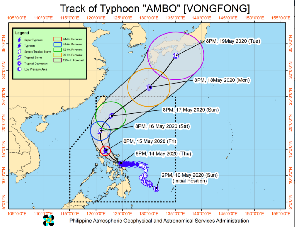
In its 5 a.m. severe weather bulletin, Pagasa said the typhoon crossed Burias Island in Masbate at 3 a.m as it continues to weaken.
Moderate to heavy with at times intense rains are expected over the Bicol region and the provinces of Quezon, Aurora and Marinduque.
Flooding and rain-induced landslides may occur in highly to very highly susceptible areas during heavy or prolonged rainfall, Pagasa warned.
At 4 a.m., the eye or center of the typhoon was located in the vicinity of Claveria, Masbate.
Article continues after this advertisementIt is moving northwest at 15 kilometers per hour (kph) and is packing maximum sustained winds of 125 kph near the center and gustiness of up to 165 kph.
Article continues after this advertisementIn the next 24 hours, storm surges with a height of up to two meters may be experienced over the coastal areas in the Bicol region, Quezon, and Aurora which may result to “potentially life-threatening coastal inundation,” according to the state weather bureau.
Sea travel is risky for all types of vessels in areas under tropical cyclone wind signals (TCWS).
“Ambo” first made landfall in San Policarpo, Eastern Samar at 12:15 p.m. Thursday, then in Dalupiri Island, Northern Samar at 10:15 p.m., Capul Island, Northern Samar at 10:30 p.m. Thursday and Ticao Island, Masbate at 12 a.m. Friday.
The typhoon is expected to weaken into a severe tropical storm on Saturday, into a tropical storm on Sunday, and further into a tropical depression on Monday. It is expected to exit PAR on Monday afternoon.
Below is the list of areas placed under TCWS No. 3, which means winds of greater than 121 kph up to 170 kph may be expected in at least 18 hours:
– Sorsogon
– Albay
– northern Masbate (Aroroy, Mandaon, Milagros, Baleno, Masbate City, Mobo, Uson) including Ticao and Burias Islands
– Camarines Norte
– western portion of Camarines Sur (Del Gallego, Ragay, Lupi, Sipocot, Libmanan, Cabusao, Pasacao, Pamplona, Gainza, Camaligan, Canaman, Magarao, Bombon, Calabanga, Tinambac, Siruma, Goa, Naga City, Milaor, San Fernando, Minalabac, Pili, Ocampo, Tigaon, Sagñay, Buhi, Iriga City, Baao, Bula, Balatan, Nabua, Bato)
– southern portion of Quezon (Pagbilao, Atimonan, Padre Burgos, Agdangan, Plaridel, Unisan, Gumaca, Pitogo, Perez, Alabat, Quezon, Tagkawayan, Calauag, Lopez, Macalelon, General Luna, Catanauan, Buenavista, Guinayangan, Mulanay, San Narciso, San Andres, San Francisco)
TCWS No. 2, which means winds of greater than 61 km/h and up to 120 km/h may be expected in at least 24 hours, is raised over the following areas:
– Nueva Vizcaya
– Quirino
– Aurora
– Nueva Ecija
– Tarlac
– Pampanga
– Bulacan
– Metro Manila
– Rizal
– Laguna
– Cavite
– Batangas
– the rest of Quezon
– the rest of Masbate
– the rest of Camarines Sur
– Catanduanes
– eastern portion of Romblon (Banton, Corcuera, Calatrava, San Agustin, Romblon, Magdiwang, San Fernando, Cajidiocan)
– western portion of Northern Samar (San Vicente, Capul, San Antonio, Allen, Victoria, San Isidro, Biri, Lavezares, Rosario, San Jose)
Meanwhile, TCWS No. 1, which means winds of 30 to 60 kph may be expected in at least 36 hours or intermittent rains may be expected within 36 hours, is raised over the following areas:
– Cagayan including Babuyan Islands
– Isabela
– Ilocos Norte
– Ilocos Sur
– La Union
– Pangasinan
– Apayao
– Kalinga
– Abra
– Mountain Province
– Ifugao
– Benguet
– Zambales
– Bataan
– Oriental Mindoro
– the rest of Romblon.
– the rest of Northern Samar
– extreme northern portion of Eastern Samar (Jipapad, Arteche, Maslog)
– northern portion of Samar (Calbayog City, Tagapul-an, Almagro, Sto. Niño. Tarangnan, Sta. Margarita, Gandara, Pagsanghan, San Jorge, San Jose de Buan, Matuguinao)
– Biliran
– extreme northwestern portion of Leyte (Calubian, San Isidro)
– extreme northeastern portion of Capiz (Pilar, Panay, Roxas, Ivisan)
– northeastern portion of Iloilo (Carles, Balasan, Estancia, Batad)
On Saturday, Typhoon Ambo is expected to bring moderate to heavy / intense rains over Cagayan Valley, Apayao, Kalinga, Mountain Province, Ifugao, Aurora, and the northern portion of Nueva Ecija.
The typhoon is forecast to be in the vicinity of Pantabangan, Nueva Ecija on Saturday morning, 45 kilometers northwest of Calayan, Cagayan on Sunday morning;, 225 kilometers north northeast of Basco, Batanes on Monday morning and 1,345 kilometers northeast of extreme northern Luzon and outside the Philippine Area of Responsibility on Tuesday morning.
RELATED STORY: Typhoon Ambo slightly weakens, but storm surges still possible–Pagasa