Taal blast alters land around lake

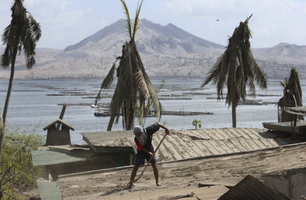
CLEANUP CONTINUES A man in Agoncillo town in Batangas province, whose village faces Volcano Island, cleans his rooftop of ash spewed by Taal Volcano. The government has allowed residents displaced by the steam-driven eruption last month to return to their homes around Taal Lake as the volcano started to quiet down in recent weeks. —MARIANNE BERMUDEZ
AGONCILLO, Batangas, Philippines — The steam-driven (phreatic) eruption of Taal Volcano last month had altered not only the iconic Volcano Island, but also the land features of its surrounding towns in Batangas province.
In the fishing village of Subic Ilaya here, residents said water from Taal Lake began to rise days after the eruption. They said the lake crept by about 20 meters inland, submerging a strip of shoreland at Sitio Manalao under 4 to 5 feet (1.21 to 1.52 m) of water.
“This has never happened before,” said resident Loreto Sanggalang, 61.
Ash-quake combination
Alice Williams, a store owner in Manalao, said their place used to be “elevated”and they had never experienced flooding.
The earthquakes shook down smaller fish ports at Barangay Banyaga where caretakers of fish cages, a common livelihood in this part of the Taal Lake, scrambled to salvage wood and iron sheets buried in the ash pile.
“We come here during the day but return to evacuation [centers] at night because there’s still no electricity,” said Jake Arugay.
He said their employer, who owned the fish cages, had sent home some of his colleagues to Cagayan Valley and Bicol regions after the business “lost big” because of the eruption.
But in other lakeshore villages of Bilibinwang and Banyaga, still in this town, water receded by a few meters, said Agoncillo Mayor Daniel Reyes.
This also happened in the adjacent town of San Nicolas after the water pushed back by at least 5 m, according to Batangas provincial administrator Levi Dimaunahan.
“The land rose in one part but sank in another,”Dimaunahan said in a separate phone interview.
He said the change in topography resulted from the “combination of the ash pile and the [series of] tremors, as if defaced by a violent punch.”
Permanently displaced
“It’s permanently damaged,” Dimaunahan said.
Reyes agreed to this, citing a similar explanation from the Philippine Institute of Volcanology and Seismology.
Reyes said at least 30 to 40 houses along Subic Ilaya alone were destroyed, with its residents joining the rest of the 6,000 people from Volcano Island, known here as “Pulo,” permanently displaced by the eruption.
The provincial government declared Volcano Island (covering about 2,475 hectares before the eruption) a permanent danger zone, prohibiting human settlement and activity on it.
Interim homes Taal Lake covered about 234 square kilometers and was shared by 12 towns and cities in Batangas.
Dimaunahan said initial post-¬eruption assessments showed that the water, on the average, moved further inland by a meter.
“We still don’t know. Some [affected residents] were planning to [reclaim the land] so they could rebuild their hou-¬ses, but we’re still not sure how [plausible] that would be,” Reyes said.
“Even if they had land titles [for the properties], I don’t think it would still be safe to live there,” Dimaunahan said.
Agoncillo, one of the har¬dest hit by the eruption, has yet to fully recover even as the alert level was downgraded to 2 on Feb. 14.
Reyes said 80 percent of the town’s power and water supply had been restored.
As of Monday, the Batangas government said 1,759 families remained in evacuation centers.
The provincial government had opened up an “interim” housing site in Ibaan town for the families displaced from Volcano Island, while they were looking for permanent resettlement areas in government properties in Balete and San Juan towns.