Pagasa: Ursula likely to make last landfall over Southern Mindoro
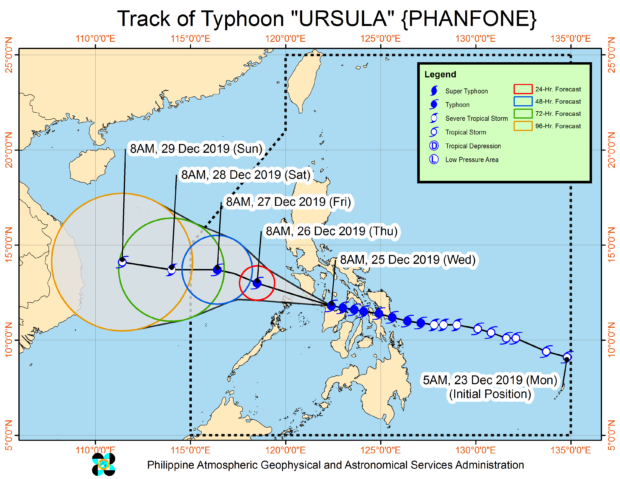
MANILA, Philippines — Typhoon Ursula was forecast to make its sixth and final landfall over the southern Mindoro provinces, the state weather bureau said Wednesday.
In its 11 a.m. weather update, the Philippine Atmospheric, Geophysical and Astronomical Services Administration (Pagasa) said the Mindoro provinces will be affected by Ursula’s eyewall in the coming hours.
Ursula was also monitored bringing very destructive winds and intense rainfall over Aklan, northern portion of Antique, and Romblon.
Pagasa said calm conditions may be initially experienced in areas where Ursula’s eye would pass through but warned that such a situation would become violent once the eye leaves the areas. The disturbance is associated with the typhoon’s eyewall, according to Pagasa.
However, Pagasa added that as the eye moves out of the area, violent conditions associated with Ursula’s eyewall will resume.
Article continues after this advertisementThe typhoon previously hit land five times in Salcedo, Eastern Samar; Tacloban, Leyte; Cabucgayan, Biliran; Gigantes Islands, Carles, Iloilo; and Ibajay, Aklan.
Article continues after this advertisementAccording to the state weather bureau, Ursula was last spotted in the vicinity of San Roque, Antique.
Ursula was packing maximum sustained winds of 140 kilometers per hour (kph) near the center and gustiness of up to 195 kph, and moving west at 20 kph.
Pagasa has raised Tropical Cyclone Wind Signal (TCWS) No. 3 over the following areas:
- Romblon
- Southern Oriental Mindoro (Roxas, Mansalay, Bulalacao, Bongabong, Bansud)
- Southern Occidental Mindoro (Calintaan, Rizal, San Jose, Magsaysay
- Southern portion of Sablayan
- Calamian Islands (Busuanga, Coron, Culion)
- Capiz
- Aklan
- Northern Antique (Caluya, Libertad, Pandan, Sebaste, Culasi, Tibiao, Barbaza, Laua-an)
Pagasa, meanwhile, placed the following areas under TCWS No. 2:
- Southern portion of Quezon (Macalelon, General Luna, Catanauan, Mulanay, San Narciso, San Andres, San Francisco)
- Marinduque
- rest of Oriental Mindoro
- rest of Occidental Mindoro including Lubang Island
- Masbate including Ticao and Burias Islands
- Cuyo Islands
- extreme northern portion of mainland Palawan (Linapacan, El Nido, Taytay, Araceli)
Iloilo - Guimaras
- rest of Antique
TCWS No. 1, on the other hand, was hoisted over the following:
- Metro Manila
- Bataan
- Rizal
- Cavite
- rest of Quezon
- Laguna
- Batangas
- Camarines Sur
- Camarines Norte
- Albay
- Sorsogon
- rest northern mainland Palawan (Dumaran, San Vicente, Roxas)
- Cagayancillo Islands
- rest of Negros Occidental
- Northern Cebu including Batayan Islands (Bantayan, Madridejos, Sta. Fe, Daanbantayan, Medelin, Bogo City, San Remigio, Tabogon, Tabuelan, Tuburan, Asturias, Carmen, Catmon, Sogod, Borbon, Tabogon)
- Negros Occidental
The state weather bureau then said occasional to frequent heavy with intermittent intense rains may be experienced over Aklan, Antique, Capiz, Romblon, Calamian Islands, Cuyo Islands, and Mindoro Provinces until Wednesday night.
Light to moderate rains with isolated heavy rain showers and thunderstorms, meanwhile, was forecast over the Bicol Region, rest of Western Visayas, Calabarzon, Marinduque, Aurora, and the northern portion of mainland Palawan.