Ursula may turn into typhoon as it inches closer to Eastern Visayas
MANILA, Philippines — Severe Tropical Storm Ursula may further intensify into a typhoon while moving closer to Eastern Visayas, the state weather bureau said Tuesday.
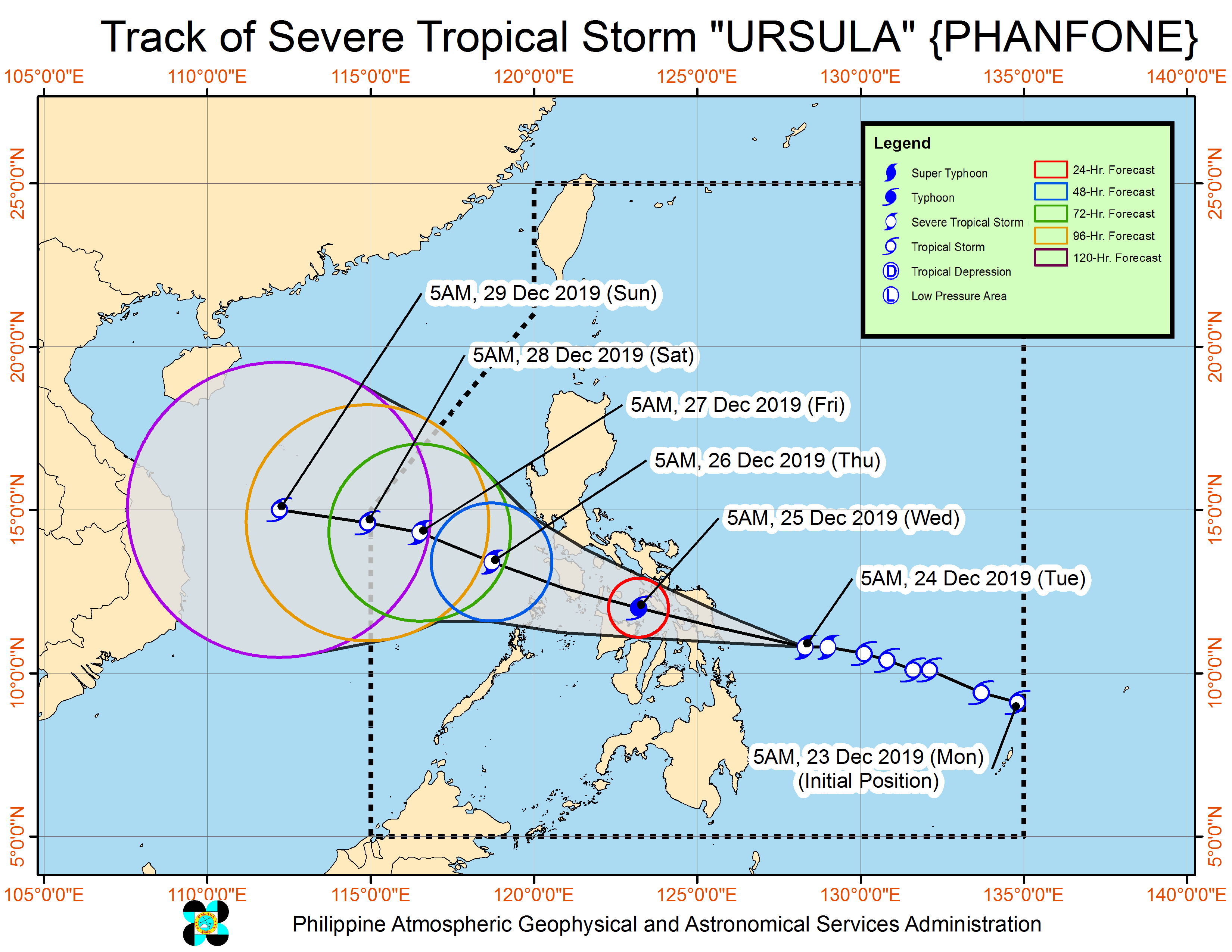
In its 8 a.m. weather update, the Philippine Atmospheric, Geophysical and Astronomical Services Administration (Pagasa) said that Ursula was last spotted at 250 kilometers east of Guiuan, Eastern Samar.
Ursula packed maximum sustained winds of 100 kilometers per hour (kph) near the center, and gusts of up to 125 kph.
The severe tropical storm was moving west at 30 kph.
Pagasa said Ursula was forecast to make landfall over Eastern Samar either Tuesday afternoon or evening, either as a severe tropical storm or a typhoon.
Article continues after this advertisementTropical Cyclone Wind Signal (TCWS) No. 2 was hoisted over the following areas:
Article continues after this advertisement- Romblon
- Albay
- Sorsogon
- Masbate including Burias and Ticao Islands
- Northern Samar
- Eastern Samar
- Samar
- Leyte
- Biliran
- Extreme northern Cebu including Bantayan and Camotes Islands (Bantayan, Madridejos,Santa Fe, Daanbantayan, Medellin, San Remigio, Bogo City, Tabogon, Tabuelan, Borbon, San Francisco, Poro, Tudela, Pilar)
- Northeastern Iloilo (Carles, Balasan, Estancia, Batad, San Dionisio, Sara, Concepcion, Lemery, Ajuy)
- Northern Antique (Libertad, Pandan, Sebaste, Culasi, Tibiao),
- Capiz
- Aklan
TWCS No. 1, meanwhile, was raised in the following areas:
- Bulacan
- Bataan
- Metro Manila
- Rizal
- Cavite
- Quezon
- Laguna
- Batangas
- Camarines Sur
- Camarines Norte
- Catanduanes
- Marinduque
- Romblon
- Occidental Mindoro including Lubang Island
- Oriental Mindoro
- Calamian Islands
- Cuyo Islands
- Southern Leyte
- the rest of northern Cebu (Carmen, Asturias, Tuburan, Catmon, Sogod)
- Central Cebu (Aloguinsan, Carcar City, Pinamungahan, San Fernando, Naga City, Toledo City, Minglanilla, Balamban, Talisay City, Cebu City, Cordova, Lapu-Lapu City, Mandaue City, Consolacion, Liloan, Compostela, Danao City)
- Northeastern Bohol (Inabanga, Danao, Dagohoy, Pilar, Guindulman, Anda, Candijay, Alicia, Buenavista, Jetafe, Talibon, Trinidad, Bien Unido, San Miguel, Ubay, Mabini, Pres. Carlos P. Garcia)
- The rest of Antique
- The rest of Iloilo
- Guimaras
- Northern Negros Occidental (Bacolod City, Bago City, Cadiz City, Calatrava, Enrique B. Magalona, Escalante City, La Carlota City, La Castellana, Manapla, Moises Padilla, Binalbagan, Hinigaran, Isabela, Murcia, Pontevedra, Pulupandan, Sagay City, Salvador Benedicto, San Carlos City, San Enrique, Silay City, Talisay City, Toboso, Valladolid, Victorias City)
- Northern Negros Oriental (Canlaon City, Guihulngan City, Jimalalud, La Libertadl Vallehermoso)
Occasional to frequent heavy rains may be experienced over Dinagat Islands, Siargao and Bucas Grande Islands, Eastern Visayas, Sorsogon, Masbate, northern and central Cebu, northern Negros Provinces, Aklan, Antique, Capiz, Iloilo, Guimaras and Romblon between Tuesday or Wednesday, Pagasa said.
Light to moderate with intermittent heavy rains was forecast over the rest of Bicol Region, Quezon, Marinduque, Oriental Mindoro, and the rest of Visayas and Surigao del Norte.