Weather double whammy: ‘Ramon’ lingers, ‘Sarah’ nears
 People in northern Luzon should brace for a weather double whammy this week, as Typhoon “Ramon” (international name: Kalmaegi) and Tropical Depression “Sarah” both threaten to bring heavy rain and strong winds in provinces in the region, the weather bureau warned on Tuesday.
The Philippine Atmospheric, Geophysical and Astronomical Services Administration (Pagasa) also warned residents of La Union and Pangasinan provinces of a possible storm surge by Wednesday due to Ramon, with wave heights that could reach up to 2 meters.
As of Tuesday afternoon, tropical cyclone wind signal No. 3 had been raised in the northern portion of Cagayan province, particularly Santa Praxedes, Claveria, Sanchez Mira, Pamplona, Abulug, Ballesteros, Aparri, Calayan, Camalaniugan, Buguey, Santa Teresita, Gonzaga and Santa Ana.
The provinces of Batanes, Apayao, Kalinga, Abra, Ilocos Norte, Ilocos Sur and the rest of Cagayan had been placed under signal No. 2.
Signal No.1 had been raised in Mountain Province, Benguet, Ifugao, La Union, Pangasinan and the northern portion of Isabela, including Santa Maria, San Pablo, Maconacon, Cabagan, Santo Tomas, Quezon, Delfin Albano, Tumauini, Divilacan, Quirino, Roxas, Mallig, San Manuel, Burgos, Gamu and Ilagan City.
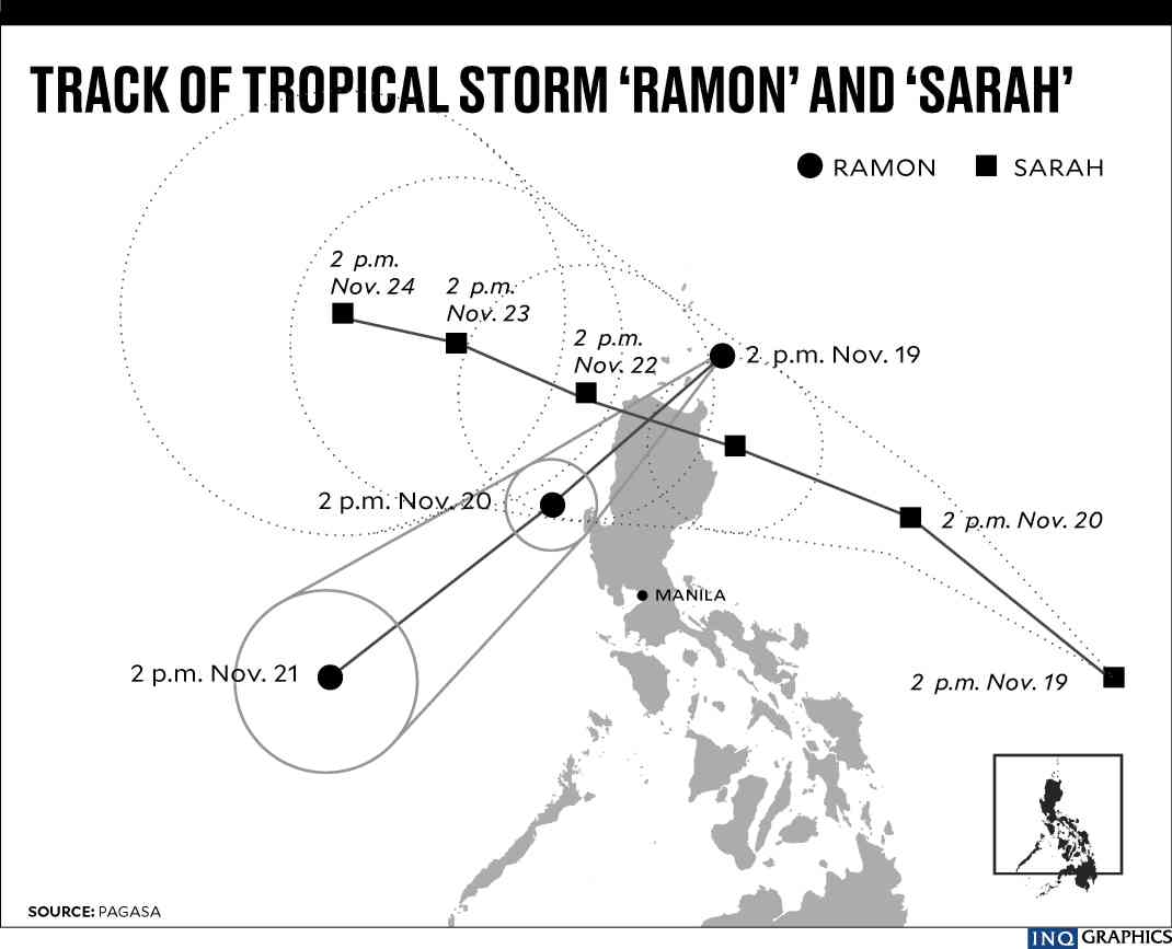
Almost stationary
As of 4 p.m. on Tuesday, Ramon was 120 kilometers east of Calayan in Cagayan province. It packed maximum sustained winds of up to 120 km per hour near the center and gustiness of up to 165 kph.
Article continues after this advertisementThroughout Tuesday, the storm remained almost stationary, according to Pagasa weather specialist Benison Estareja.
Article continues after this advertisementBut following its forecast track, Ramon was expected to hit land between Tuesday night and Wednesday morning, blowing over Cagayan, Apayao and Ilocos Sur provinces.
More than 5,000 people in Cagayan jammed evacuation centers as Ramon approached land, provincial information officer Rogelio Sending Jr. said.
Gov. Manuel Mamba said schools remained shuttered and liquor prohibited on Tuesday.
Rueli Rapsing, chief of the provincial government’s rescue team, said electricity had been cut in Santa Ana and Gonzaga as a precaution.
On Wednesday, light to moderate rain, occasionally getting heavy, will prevail in Batanes, the northern portion of Cagayan, including Babuyan Islands, and Apayao.
Light to moderate rain, intermittently getting heavy, is expected in Isabela, the rest of Cagayan, northern portion of Aurora, Kalinga and Ilocos Norte.
Estareja said that after making landfall, Ramon was expected to weaken into a tropical storm, and could exit the Philippine area of responsibility as low pressure on Thursday.
Stormy weekend
As Ramon leaves, however, Sarah is expected to slam into the same parts of northern Luzon toward the weekend.
Estareja said Sarah could intensify into a tropical storm, and also make landfall in Cagayan by Thursday.
As of 4 p.m. on Tuesday, Sarah was 710 km east of Virac, Catanduanes province, packing winds up to 55 kph and gusts up to 70 kph.
It was moving much faster than Ramon at 35 kph, heading northwest. If it maintains its speed, it is expected to leave the country’s area of responsibility by the weekend.