Typhoon likely to enter PAR by Wednesday or Thursday — Pagasa |
'WUTIP' APPROACHING PHILIPPINES

Typhoon likely to enter PAR by Wednesday or Thursday — Pagasa

By: - Reporter / @KAguilarINQ
/ 11:23 AM February 25, 2019

Typhoon likely to enter PAR by Wednesday or Thursday — Pagasa

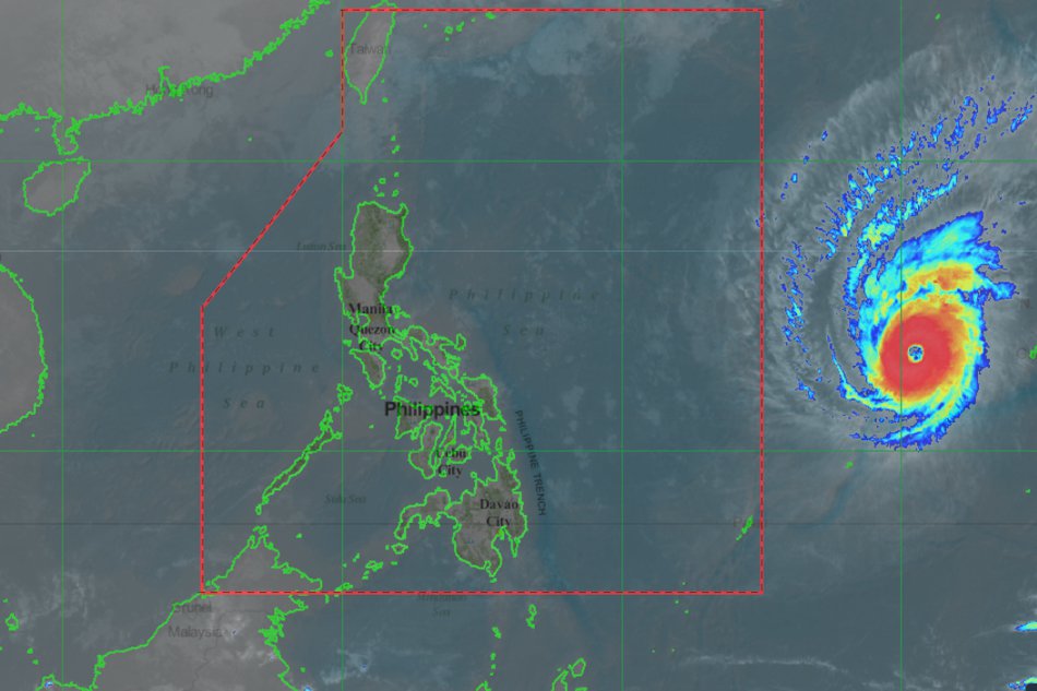
MANILA, Philippines — A new typhoon was spotted moving towards the Philippine area of responsibility (PAR), the state weather bureau said Monday. 

The typhoon, which international name is “Wutip,” was last seen 1,815 kilometers east of Southern Luzon and moving northwest at 10 kilometre per hour (kph), according to the Philippine Atmospheric, Geophysical and Astronomical Services Administration (Pagasa). 

Article continues after this advertisement

Pagasa said Wutip was packing maximum sustained winds of 185 kph near the center and gustiness of up to 225 kph.

Pagasa weather specialist Ezra Bulquerin said Wutip would likely enter PAR on Wednesday or Thursday.

Meanwhile, Pagasa said the northeast monsoon or “amihan” was still affecting the country. It said provinces of Aurora and Quezon as well as Bicol region could expect partly cloudy to cloudy skies with isolated rain due to amihan. /kga
Your subscription could not be saved. Please try again.
Your subscription has been successful.

Subscribe to our daily newsletter

By providing an email address. I agree to the Terms of Use and acknowledge that I have read the Privacy Policy.

TAGS: Local news, Nation, national news, News, Typhoon, Weather, Wutip

Your subscription could not be saved. Please try again.
Your subscription has been successful.

Subscribe to our newsletter!

By providing an email address. I agree to the Terms of Use and acknowledge that I have read the Privacy Policy.

© Copyright 1997-2024 INQUIRER.net | All Rights Reserved

This is an information message

We use cookies to enhance your experience. By continuing, you agree to our use of cookies. Learn more here.