Several areas in Luzon under warning signals as ‘Rosita’ nears landfall
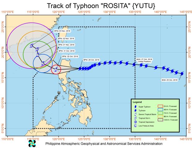
Track of Rosita as of 11:00 p.m. on Monday, Oct. 29, 2018
Typhoon “Rosita,” internationally known as “Yutu,” maintained it strength late Monday night hours before its expected landfall somewhere in southern Isabela province and northern Aurora province between 5:00 a.m. and 7:00 a.m. on Tuesday.
As of 10:00 p.m. on Monday, the eye of the typhoon was located 190 km east-northeast of Casiguran, Aurora, according to the bulletin issued at 11:00 p.m. on Monday by the Philippine Atmospheric, Geophysical and Astronomical Services Administration (Pagasa).
The typhoon is expected to go through Aurora, Isabela, Quirino, Ifugao, Nueva Vizcaya, Benguet and La Union.
It will probably exit landmass by Tuesday afternoon and leave the Philippine area of responbility by Wednesday evening.
Meanwhile, Pagasa has raised tropical cyclone warning signals in several parts of Luzon, including Metro Manila,
Following are the areas place under warning signals:
Signal No. 3
- Isabela
- Quirino
- Northern Aurora
- Nueva Vizcaya
- Ifugao
- Benguet
- La Union
- Ilocos Sur
- Mountain Province
- Pangasinan
Signal No. 2
- Cagayan
- Ilocos Norte
- Apayao
- Abra
- Kalinga
- Tarlac
- Nueva Ecija
- Northern Quezon including Polillo Island
- Southern Aurora
- Zambales
- Pampanga
- Bulacan
Signal No. 1
- Southern Quezon
- Batanes and Babuyan group of Islands
- Rizal
- Metro Manila
- Laguna
- Batangas
- Bataan
- Cavite
- Camarines Norte
Areas under warning signals will have winds of varying speeds:
- Signal No. 3: Winds of greater than 121 kph up to 170 kph may be expected in at least 18 hours.
- Signal No. 2: Winds of greater than 61 kph and up to 120 kph may be expected in at least 24 hours.
- Signal No. 1: Winds of 30-60 kph may be expected in at least 36 hours or intermittent rains may be expected within 36 hours.
Travel by land is risky over areas under Signal Nos. 2 and 3.
Residents in these areas, especially those living near rivers or those in low-lying and mountainous areas, are advised to take precautions against
possible flooding and landslides. They should alsoi coordinate with the local disaster risk reduction and management offices.
Storm surge of up to 3 meters is possible in the coastal areas of Isabela, Cagayan, Aurora, Ilocos Sur, Ilocos Norte and La Union.
Fisherfolks and those with small seacrafts are advised not to venture out over the seaboards of areas with warning signals and eastern and western seaboards of Southern Luzon and the eastern seaboards of Visayas and Mindanao. /atm