Pagasa says Aghon was last spotted in the area traversing in a northeastward direction slowly. (Photo courtesy of Pagasa)
MANILA, Philippines — Tropical storm Aghon (international name: Ewiniar) maintained its strength as it slowly moved over Mauban, Quezon on Sunday afternoon, the state weather bureau reported.
In its latest cyclone update, the Philippine Atmospheric, Geophysical and Astronomical Services Administration (Pagasa) said Aghon was last spotted in the area traversing in a northeastward direction slowly.
READ: Aghon heading to Sariaya, Quezon; signal # 2 up in 4 Luzon provinces
The tropical storm is carrying maximum sustained winds of 75 kilometers per hour (kph) near the center with gustiness of up to 125 kph.
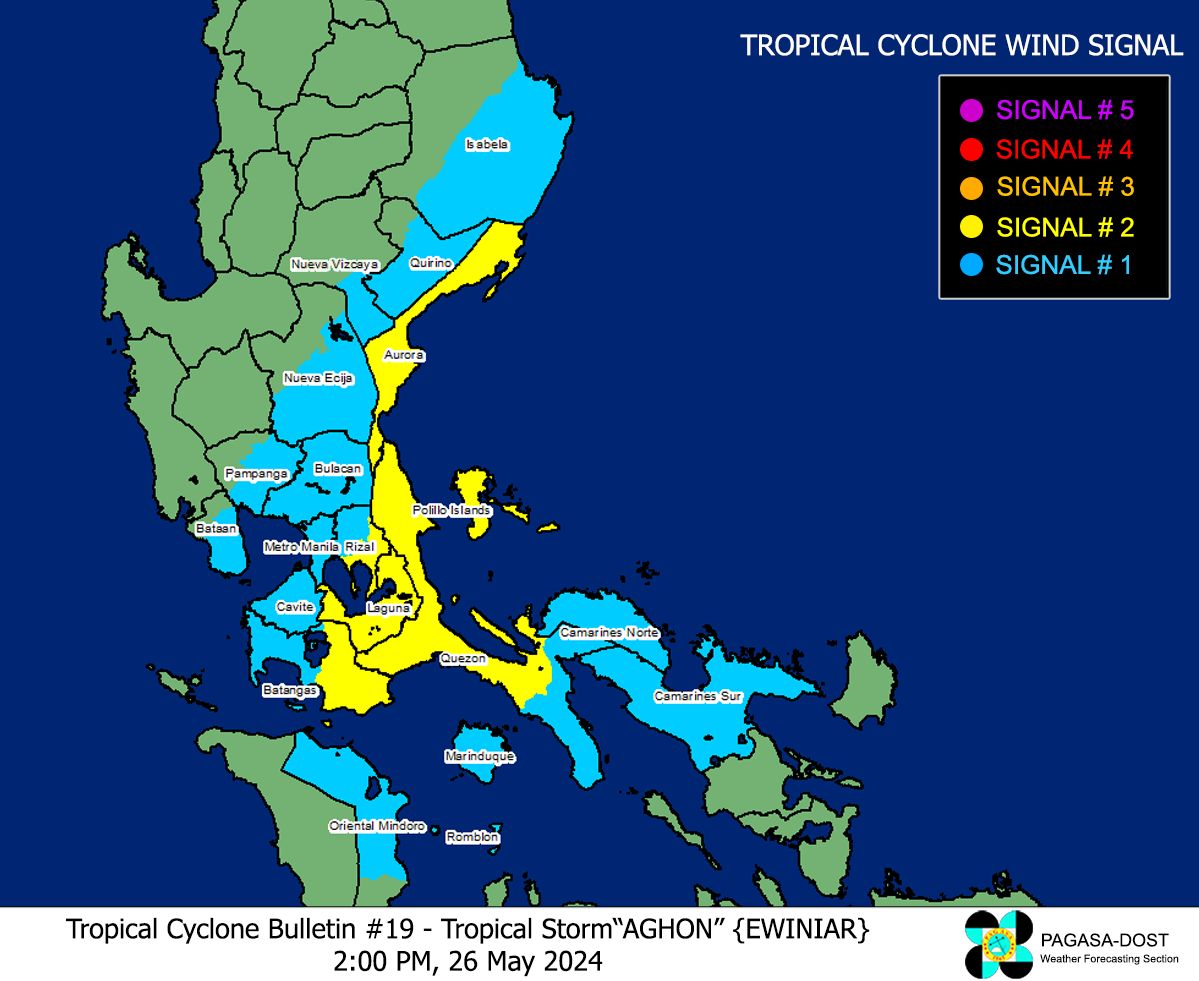
With this development, Pagasa said that a Tropical Cyclone Wind Signal (TCWS) Number 2 remains up in the following areas:
- Aurora
- Northern and central portions of Quezon (Alabat, Perez, Quezon, Gumaca, Lopez, Macalelon, General Luna, Unisan, Pitogo, Plaridel, Agdangan, Padre Burgos, Atimonan, Mauban, Real, General Nakar, Infanta, Sampaloc, Pagbilao, Calauag, Lucban, City of Tayabas, Lucena City, Tiaong, Candelaria, Sariaya, Dolores, San Antonio) including Polillo Islands Laguna
- Eastern portion of Batangas (City of Tanauan, San Jose, Lipa City, Mataasnakahoy, Balete, Malvar, Santo Tomas, Cuenca, San Pascual, Batangas City, Ibaan, Padre Garcia, Rosario, San Juan, Taysan, Lobo)
- Eastern portion of Rizal (Jala-Jala, Pililla, Tanay, Cardona, Binangonan, Morong, Baras)
Meanwhile, TCWS Number 1 is still hoisted in the areas listed below:
- Eastern portion of Isabela (Divilacan, San Mariano, San Guillermo, Jones, Echague, San Agustin, Ilagan City, Benito Soliven, City of Cauayan, Maconacon, Angadanan, Naguilian, Palanan, Dinapigue)
- Eastern portion of Quirino (Maddela, Nagtipunan, Aglipay)
- Southern portion of Nueva Vizcaya (Alfonso Castaneda, Dupax del Sur, Dupax del Norte), The eastern and southern portions of Nueva Ecija (General Tinio, Gabaldon, Bongabon, Pantabangan, Rizal, General Mamerto Natividad, Laur, Palayan City, Peñaranda, San Leonardo, City of Gapan, Cabanatuan City, Santa Rosa, San Isidro, Cabiao, San Antonio, Jaen, Zaragoza, Aliaga, Talavera, Llanera)
- Southern portion of Bataan (Orani, Samal, City of Balanga, Abucay, Pilar, Orion, Limay, Mariveles, Bagac)
- Eastern portion of Pampanga (Candaba, San Luis, San Simon, Apalit, Santa Ana, Arayat, Mexico, Santa Rita, Guagua, Sasmuan, Macabebe, Masantol, Santo Tomas, Minalin, City of San Fernando, Bacolor, Lubao)
- Bulacan
- Metro Manila
- Rest of Quezon
- Rest of Rizal
- Cavite
- Rest of Batangas
- Northern and central portions of Oriental Mindoro (Pinamalayan, Pola, Naujan, Victoria, Socorro, City of Calapan, Bansud, Gloria, Baco, San Teodoro, Puerto Galera, Bongabong), Marinduque
- Extreme northern portion of Romblon (Concepcion, Corcuera, Banton), Camarines Norte, and Camarines Sur
Based on the report, the state weather bureau said that there is a minimal to moderate risk of storm surge over the exposed and low-lying coastal areas of Cagayan, Isabela, Central Luzon, Metro Manila, Calabarzon, Mindoro Provinces, Marinduque, Romblon, Camarines Norte, Camarines Sur, and Burias Island over the next 24 hours.
The storm’s winds also prompted Pagasa to raise a gale warning over the coastal waters of Aurora, Quezon, and Marinduque, the southern coastal waters of Batangas, and the northern coastal waters of Camarines Norte.