‘Seniang’ raises fears of floods, slides in South
MANILA, Philippines–Mindanao and the Visayas will have rains, floods and landslides in the closing days of the year as a tropical cyclone crosses the region this week, according to the weather bureau.
Tropical Depression “Seniang” (no international name yet) will cross northeastern Mindanao and areas of the Visayas throughout this week, bringing moderate to heavy rains and gusty winds, the Philippine Atmospheric, Geophysical and Astronomical Services Administration (Pagasa) said on Sunday.
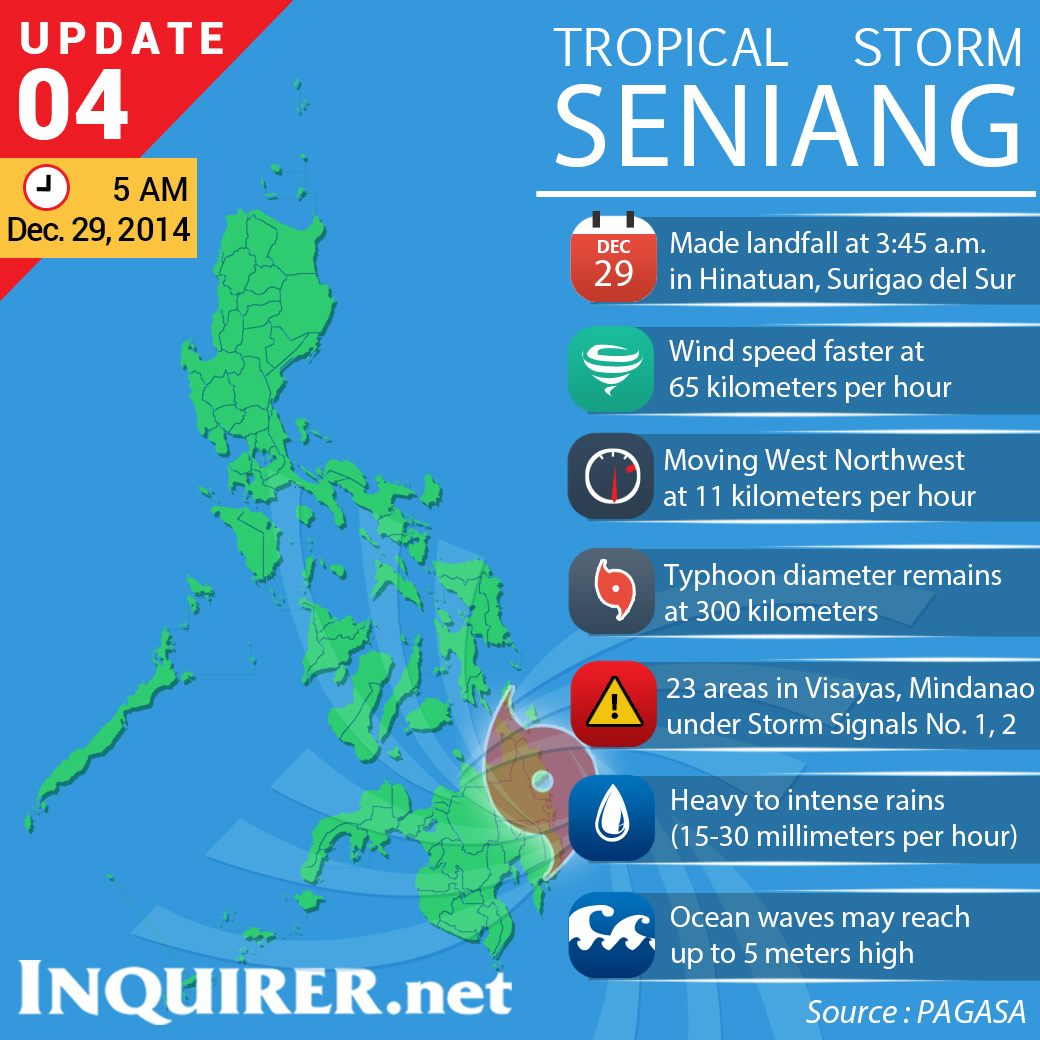
As it neared the Mindanao landmass Sunday, Seniang slightly intensified, with maximum winds of up to 55 kilometers per hour (kph), picking up from 45 kph, and slightly gained speed, 13 kph from 11 kph, moving west-northwest, Pagasa said.
In a news conference Sunday afternoon, Pagasa weather division chief Esperanza Cayanan said the bureau had issued flood advisories to the affected provinces in the Visayas and Mindanao.
“[W]e should be alert and be on our guard, especially those living in mountainous areas,” Cayanan said.
She said the affected areas had been having rains in the past days “so there’s a big chance of landslides.”
Pagasa weather forecasting section chief Rene Paciente said the cyclone would further intensify during the week into the lower end of storm category with sustained winds reaching up to 65 kph and moderate to heavy rains with occasional intense rains.
It is the 19th weather disturbance to affect the country this year, only three weeks since Typhoon “Ruby” (international name Hagupit) slammed into Eastern Visayas and Southern Luzon, leaving at least 19 people dead and nearly 1,000 injured.
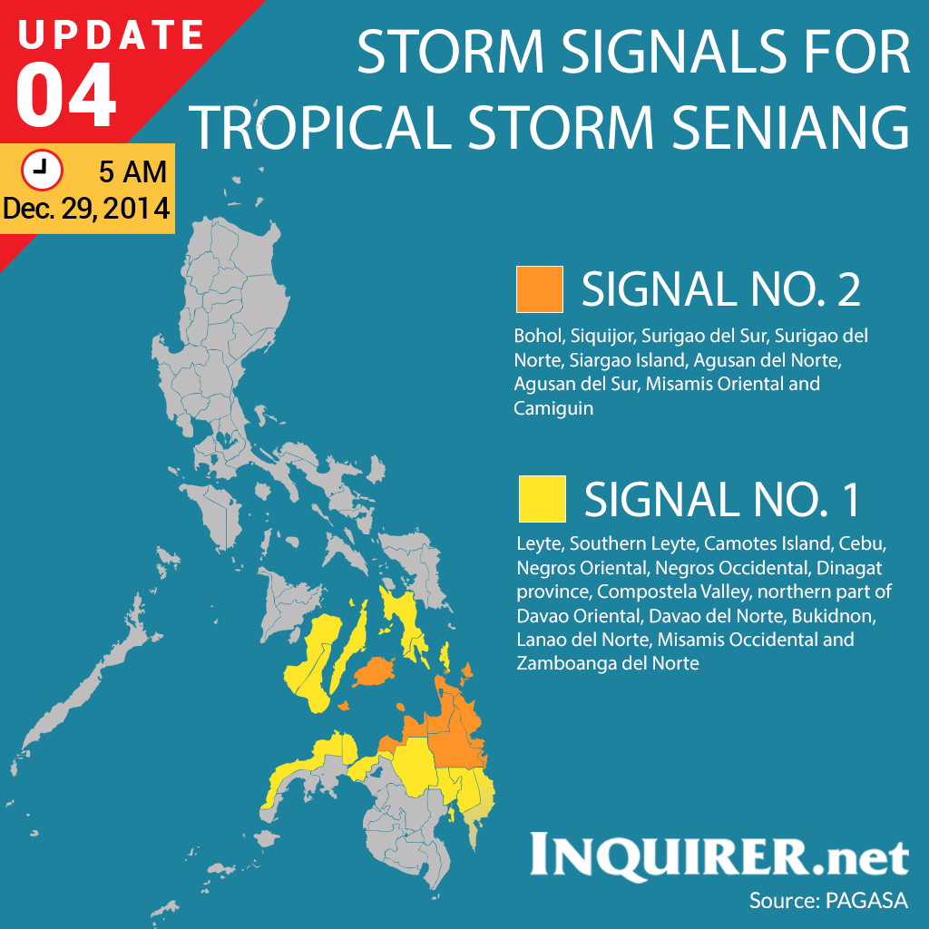
Storm signal no. 1
On Sunday afternoon, Pagasa expanded the areas under Public Storm Warning Signal Number 1, covering Leyte, Southern Leyte, Camotes Island, Cebu, Bohol, Negros Occidental and Siquijor provinces in the Visayas and the provinces of Surigao del Norte, Surigao del Sur, Dinagat, Siargao Island, Agusan del Norte, Agusan del Sur, northern part of Davao Oriental, Davao del Norte, Davao Oriental, Compostella Valley, Camiguin Island, Misamis Oriental, Misamos Occidental, Lanao del Norte, Zamboanga del Norte and Bukidnon in Mindanao.
Pagasa said Seniang would make its first landfall in the morning of Dec. 29 in Tandag, Surigao del Sur. Provinces within a 300-km diameter from the cyclone’s center will experience moderate to heavy rainfall and occasional gusty winds, the bureau said.
Pagasa alerted residents in low-lying and mountainous areas of the provinces under Signal No. 1, as well as those in the Eastern Visayas region and the rest of Mindanao, especially the Caraga region, against flash floods and landslides.
Evacuations
Already, at least 19 houses were damaged and dozens of families fled their homes in several parts of Compostela Valley as rains lashed Southern Mindanao.
At least 33 families fled to safer grounds amid threat of flooding in Nabunturan and Compostela town, Compostela provincial disaster action officer Raul Villocino said yesterday.
In Monkayo, Compostela Valley, more than a dozen families were evacuated as landslide hit Sitio (settlement) Bosquit in San Jose village around 2 a.m., municipal information officer Joan Pintal said.
The landslide displaced 71 people, but no one was injured, Pintal said.
Local disaster councils in Davao del Norte were placed on alert as rivers in the province began to swell.
Bad weather forced the suspension of sea travel Sunday, stranding 1,301 travelers at the ports in Bohol province.
Lt. Junior Grade Robinson Madriaga, head of the Philippine Coast Guard station in Bohol, said ferries headed for Cebu, Siquijor and Maasin City in Southern Leyte were grounded.
No trips would be allowed until after storm signals had been lifted, Madriaga said.
Out Jan. 2
Seniang developed from low pressure that entered the Philippine area of responsibility on Dec. 26.
By Monday afternoon, Pagasa said, the center of the cyclone will be about 110 km north-northeast of Lumbia.
By Tuesday, the center of the cyclone will be about 100 km west of Dipolog City.
By New Year’s Eve, the cyclone’s center is expected to be about 190 km southeast of Puerto Princesa City, Palawan.
The cyclone is expected to be over the West Philippine Sea by Jan. 1 and out of the Philippine area of responsibility by early Jan. 2.–With reports from Frinston L. Lim, Inquirer Mindanao, and Carmel Loise Matus, Inquirer Visayas