Brace for Typhoon ‘Ruby’ impact
Powerful Typhoon “Ruby” (international name: Hagupit) slams into Eastern Visayas this afternoon for a four-day crossing of central Philippines, affecting the capital Metro Manila, that is likely to affect 32 million people—a third of the country’s population.
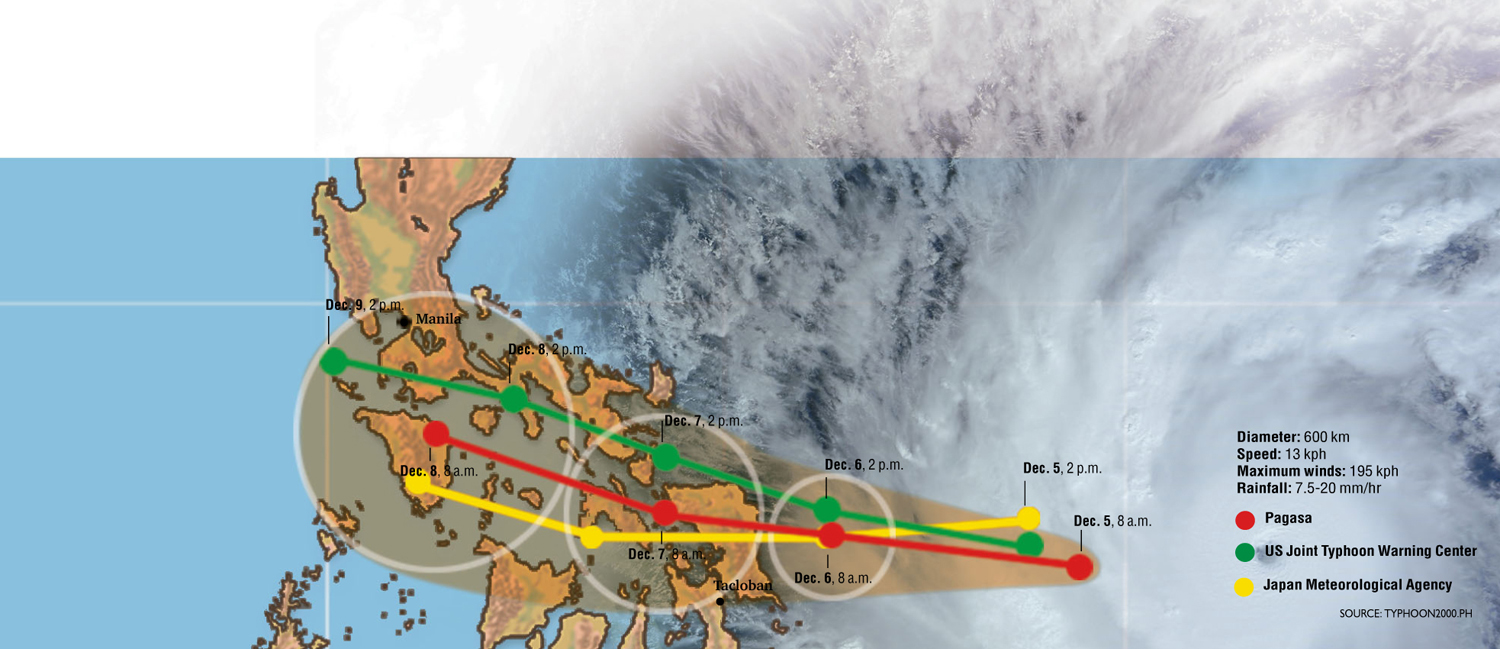
Ruby will cut slowly across the Visayas while affecting the Bicol region and southern Luzon, including Metro Manila, moving west-northwest at 13 kph toward the western seaboard.
That is so slow that Pagasa said it expected Ruby to clear the country as late as Wednesday morning.
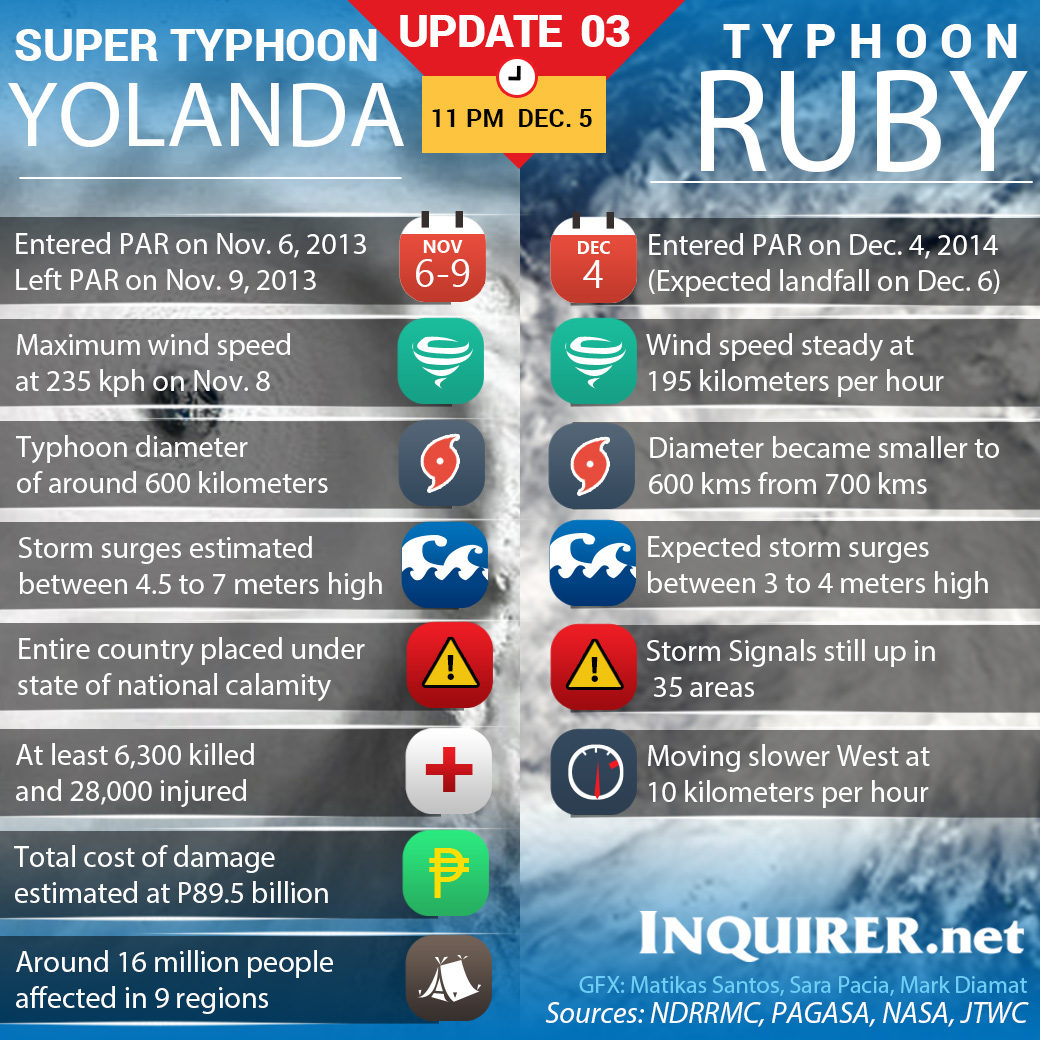
Most of the communities in Ruby’s path are the very same parts of the Central Visayas that were flattened by Supertyphoon “Yolanda” (international name: Haiyan) on Nov. 8 last year.
The Joint Typhoon Warning Center (JTWC) in Hawaii downgraded Ruby from a supertyphoon early Friday, reporting its wind strength at 240 kilometers per hour as it tracked toward land in the Philippines.
Article continues after this advertisementStill, this would make Ruby the strongest typhoon to hit the Philippines this year, with life-threatening winds, storm surges and flash floods.
Article continues after this advertisementAll-out prep
Alexander Pama, Office of Civil Defense administrator, said the government would not cut back preparations even if the Ruby had weakened.
“We are not lowering our alert levels even if the typhoon has weakened. We will continue our instructions and disseminations in different regions until the state weather bureau does not advise us so. Preparations will continue at all levels,” Pama said.
So far, more than 100,000 families have been evacuated, mostly in Western Samar, where there are more than 50,000 evacuees, Social Welfare Secretary Dinky Soliman said.
She said Yolanda served as a lesson to the residents there, who did not need any more convincing to flee their homes even before a typhoon hits.
“In [Eastern Visayas], the people themselves are preparing and do not think twice about leaving their houses. They know what to do,” she said.
The Department of Social Welfare and Development (DSWD) has also prepositioned food packs in bulk in local governments, which will repack these for distribution to evacuees.
But Soliman expressed concern about the local governments’ capability to distribute the food packs to “the rightful beneficiaries.”
The previous strongest storm this year was Typhoon “Glenda” (international name: Rammasun), which killed 106 people when it cut across Manila and other parts of Luzon in July.
The Philippine Atmospheric, Geophysical and Astronomical Services Administration (Pagasa) said Ruby would make landfall in the Northern Samar-Eastern Samar area with maximum sustained winds of 195 kph and gusts of up to 230 kph.
Yolanda, which brought maximum sustained winds of more than 300 kph and generated giant storm surges, left more than 6,300 people dead and thousands injured or missing.
The strongest typhoon ever to hit land on record, Yolanda also displaced hundreds of thousands of people across the Visayas region.
Storm surges 4 to 5 meters
Pagasa warned that Ruby, with its powerful winds only slightly less than Yolanda’s, could generate storm surges 4 meters to 5 meters high, which could worsen flash floods.
The UN Global Disaster Alert System said on Thursday that almost 32 million people, a third of the Philippines’ population, were likely to be affected in some way by Ruby’s cyclone-force winds when the storm arrives this afternoon.
“This storm is not going to be quite as strong as Haiyan, but the probability is it has the potential to impact some of the same areas that were impacted last year,” said Ari Sarsalari, a meteorologist for The Weather Channel.
“By this weekend, you guys be aware, because this is definitely the type of situation that can get very ugly,” Sarsalari said.
Course clarified
Some weather agencies had suggested earlier that Ruby could take a northerly course skirting the country. But by 5 a.m. Friday, the Philippine and Japanese national weather bureaus and the JTWC—the joint weather station of the US Navy and the US Air Force in Hawaii—all said its course had clarified and agreed that it was most likely to remain on course for central Philippines.
Ruby’s slow movement is expected to cause significant problems, including rainfall totals Sarsalari called “extraordinarily high,” causing landslides, debris flows and life-threatening flash floods.
Storm signals in 36 provinces
On Friday, Pagasa raised storm signals in 36 provinces and localities mostly in the Visayas.
Forty-two coastal municipalities were also alerted for storm surge based on simulations run by Project Noah (Nationwide Operational Assessment of Hazards).
The Samar provinces will take the brunt of the strong winds, flash floods and storm surges, Pagasa said.
The eye of the storm will remain over the Samar provinces for 24 hours, it said.
By Sunday afternoon, it said, the center of the storm will be in the vicinity of Masbate province and Ticao Island so the surrounding provinces will feel the brunt of the storm.
Potential high-risk areas
By Monday afternoon, the eye of the storm will be in the vicinity of Calapan City, Oriental Mindoro province, Pagasa said.
Since Ruby has a 600-kilometer diameter, 16 provinces were considered “potential high-risk areas,” Pagasa said.
These provinces are Bataan, Batangas, Cavite, Laguna, Quezon, Marinduque, Occidental Mindoro, Oriental Mindoro, Romblon; Albay, Camarines Norte, Camarines Sur, Masbate, Sorsogon, Biliran, Eastern Samar, Northern Samar and Samar.
These areas, which are within the 100-km radius of the typhoon’s center, could have storm surges of up to 4 meters high, sustain heavy damage to agriculture and considerable damage to structures of light and medium materials.
The storm’s powerful winds could also uproot large trees, destroy houses made of light materials, cut power and make travel by land, air and sea dangerous, Pagasa said.
Metro Manila at risk
Fourteen other provinces are also considered potential high-risk areas, as they are within the 200-km radius of the typhoon.
These are Metro Manila, Aurora, Bataan, Bulacan, Nueva Ecija, Pampanga, Tarlac, Zambales, Batangas, Rizal, Palawan, Catanduanes, Aklan, Antique, Capiz, Iloilo, Negros Occidental, Cebu and Leyte.
These areas are foreseen to experience storm surges of up to 4 meters high, moderate damage to agriculture, large trees uprooted, a large number of houses made of light materials damaged, some old galvanized iron roofing destroyed, and risky travel by sea.
Pagasa listed 10 other provinces as potential risk areas that may incur some damage since they are within the 350-km radius of the typhoon.
These are Benguet, La Union, Pangasinan, Nueva Vizcaya, Quirino, Guimaras, Bohol, Negros Oriental, Surigao del Norte and Surigao del Sur.
Storm signals No. 2 and 3
Friday night, Pagasa raised Storm Signal No. 3 in Northern Samar, Eastern Samar and Samar.
Signal No. 2 is raised in Albay, Sorsogon, Ticao Island and Masbate in Luzon; Biliran, Leyte, Southern Leyte, Northern Cebu including Cebu City, Bantayan Island and Camotes Island in the Visayas.
These areas can expect stormy weather and winds of up to 100 kph within 24 hours, Pagasa said.
Such winds are capable of destroying rice and corn fields, uprooting large trees, damaging houses made of light materials and blowing off old galvanized-iron roofs and billboards.
Pagasa warned against all sea travel in the region and of possible flash floods and landslides in low-lying and mountainous areas.

Signal No. 1
The weather bureau placed the following provinces under Storm Signal No. 1, saying these can expect occasional rains and occasional gusty winds of up to 60 kph in the next 36 hours: Catanduanes, Camarines Norte, Camarines Sur, Burias Island and Romblon in Luzon; Capiz, Iloilo, Antique, Guimaras, Aklan, Negros Oriental, Negros Occidental, the rest of Cebu, Siquijor and Bohol in the Visayas; and Surigao del Sur, Agusan del Norte, Surigao del Norte, Dinagat Island, Siargao Island, Agusan del Sur and Camiguin Island in Mindanao.
Flood warnings
Project Noah warned 42 municipalities in Samar, Leyte, Biliran, Cebu, Iloilo, Negros Occidental Masbate of storm surges of up to 4 meters high.
On its website blog.noah.dost.gov.ph and beta.noah.dost.gov.ph, Project Noah posted hazard maps that showed how far inland the floodwaters caused by storm surges will go, guiding residents where to go during evacuation.
The areas that can expect storm surges reaching over 3 meters are Talalora and Sta. Rita, Samar; Babatngon, Barugo and San Miguel, Leyte; Caibiran, Cabucgaya and Culaba, Biliran; San Remigio and Medellin, Cebu.
The areas that can expect storm surges of up to 3 meters high are Tarangnan, Catbalogan, Gandara and Sta. Margarita, Samar.
The areas where the storm surges will reach about 2 meters high are Uson and Mobo, Masbate; Sta. Fe, Bantayan and Tabuelan, Cebu; Daram, Samar; Carigara, Leyte; Esperanza and Pio V. Cruz, Masbate; Tuburan, Cebu; San Dionisio, Batad, Estancia, Iloilo; Leyte, Capoocan and Merida, Leyte; Kawayan, Maripipi and Almeria, Biliran; Dimasalang and Batuan, Palanas, Cawayan and Placer, Masbate; Carles, Iioilo; Daanbantayan and Madridejos, Cebu; and Sagay, Negros Occidental. With reports from Julie M. Aurelio, ABC News and AFP
RELATED STORIES
Typhoon ‘Ruby’ maintains strength; Signal number 3 up in Samar provinces