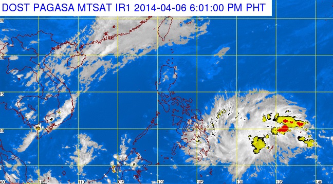
Storm ‘Domeng’ enters PAR, may turn into typhoon
MANILA, Philippines — Tropical Storm “Domeng” (international name Peipah), which entered the Philippine area of responsibility Sunday night, is expected to bring rains over parts of the Visayas and Mindanao on Monday.
Forecasters of the Philippine Atmospheric, Geophysical and Astronomical Services Administration (Pagasa) said that “Domeng” could still intensify into a typhoon before making landfall on Wednesday.
Weather forecaster Meno Mendoza said that as of 4 p.m. Sunday, “Domeng” was at 1,020 kilometers east of General Santos City, moving west-northwest at 20 kilometers per hour, with maximum sustained winds of 65 kilometers per hour and gustiness of up to 80 kilometers per hour.
Mendoza said that moderate to heavy rains (5 mm to 15 mm per hour) would fall within the 400-kilometer diameter of the storm.
According to the weather forecaster, should the tropical storm maintain its current speed and track, it will be at 570 kilometers east of Davao City by Monday afternoon and 180 kilometers east of Surigao City by Tuesday. On Wednesday afternoon, it is expected to be in the vicinity of Cebu City.
Article continues after this advertisementHe said that they were expecting “Domeng” to make landfall on Wednesday somewhere in the Eastern Visayas.
Article continues after this advertisement“If it changes track, it could go higher and pass through Southern Luzon and even Metro Manila,” Mendoza pointed out.
He said that the weather bureau has not discounted the possibility that the storm could further gain strength while over water.
In its forecast for Monday, Pagasa said that Mindanao and the regions of the Cagayan Valley as well as the Eastern and Central Visayas would have cloudy skies with scattered rainshowers and thunderstorms while Metro Manila and the rest of the archipelago would be partly cloudy to cloudy with isolated rainshowers or thunderstorms mostly in the afternoon or evening.
Moderate to strong winds will prevail over the northern and eastern sections of the country where coastal waters will be moderate to rough. Elsewhere, winds will be light to moderate with slight to moderate seas. With a report from Frances Mangosing
Originally posted at 6:30 pm | Sunday, April 6, 2014
RELATED STORIES
‘Domeng’ expected to enter PH Sunday
