Signal No. 2 up in parts of Luzon—Pagasa

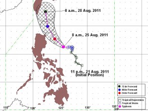
PAGASA Track as of 8 a.m., 25 August 2011
MANILA, Philippines – Signal No. 2 was raised in several provinces in Luzon while more were placed under Signal No. 1 as Typhoon “Mina” (international name: Nanmadol) intensified and continued to threaten Northern Luzon, the state-run weather bureau said Thursday.
As of 4 p.m., Mina was seen 360 kilometers east of Casiguran, Aurora and was packing maximum sustained winds of 140 kilometers per hour near the center and gusts of up to 170 kph, the Philippine Atmospheric, Geophysical and Astronomical Services Administration (Pagasa) said.
Mina was forecast to move west-northwestward at 7 kph.
Signal No. 2 is up over Northern Aurora, Isabela and Cagayan while Signal No.1 was raised in Nueva Ecija, Nueva Viscaya, Quirino, Ifugao, Mt. Province, Kalinga, Apayao, Calayan, Babuyan, Batanes Group of Islands and the rest of Aurora province.
Residents living in low-lying and mountainous areas in provinces having signal warnings were warned against possible flashfloods and landslide, Pagasa said. Likewise, those living along coastal areas were alerted against storm surges generated by the typhoon.
Article continues after this advertisementMina was forecast to enhance the southwest monsoon and bring scattered to widespread rains over the western section of Southern Luzon and Visayas.
Article continues after this advertisementEstimated rainfall is 15 to 25 millimeters per hour within the 500-km diameter of Mina, Pagasa added.
By Friday afternoon, Mina is forecast to be 150 km northeast of Casiguran, Aurora and by Saturday afternoon, 210 kilometers north-northeast of Tuguegarao City or 110 km southeast of Basco, Batanes. By Sunday afternoon, Mina will be 160 km north of Basco, Batanes, Pagasa said.
But Pagasa weather forecaster Ricky Fabregas said a high pressure area north of the Philippines was preventing Mina from exiting the Philippine area of responsibility.
Likewise, a tropical cyclone outside of the Philippine territory is also affecting Mina’s movement although the typhoon isn’t expected to make landfall, Fabregas said.