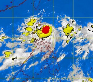
LPA to lessen ‘Nando’ rainfall, but storm signal up in North
MANILA, Philippines—A low pressure area (LPA) in the West Philippine Sea (South China Sea), seemingly caught in a tug-of-war with Tropical Storm “Nando” (international name: Kong-Rey), has considerably lessened the amount of rain that would have been spawned by the enhanced habagat and dumped on parts of Luzon.
The development was considered “good” by the weather bureau in terms of rainfall amount, but Nando is still expected to intensify while it remains over the ocean until it exits the Philippine area of responsibility (PAR) late Thursday afternoon.
The Philippine Atmospheric, Geophysical and Astronomical Services Administration (Pagasa) hoisted public storm warning Signal No. 1 over the Batanes group of islands; Cagayan including Calayan and the Babuyan group of islands; Isabela, and Apayao, and warned fishermen against going out to the eastern seaboard of Central and southern Luzon.
In a press briefing Monday, weather specialist Christopher Perez said that as of 4 p.m. the storm was 270 kilometers east of Casiguran, Aurora, with maximum sustained winds of 65 kilometers per hour near the center and gustiness of up to 80 kph.
Nando, he said, is anticipated to continue moving northwest at 15 kph and the estimated amount of rainfall within its 400-kilometer diameter will be heavy to intense at 10 millimeters to 20 mm per hour. It is not expected to make landfall while within the PAR.
Article continues after this advertisementPerez said that in northern Luzon areas where Signal No. 1 is in effect, moderate to heavy rains and winds of 45 to 60 kph are to be expected.
Article continues after this advertisementWhile the storm is anticipated to enhance the habagat (southwest monsoon), which would bring light to occasionally heavy rains and thunderstorms in Metro Manila, southern Luzon and portions of Western Visayas, the amount of rainfall would not be as much as last week because of an LPA over the West Philippine Sea. The LPA is still outside the PAR.
“One factor for expecting less rain is the LPA pulling on and preventing the movement of the habagat toward the eastern side of the country. It is basically getting the source of moisture (rain),” he explained, adding that Nando was also tugging at the southwest monsoon from the other side.
He said that unlike last week, where the habagat was enhanced by the almost stationary Tropical Storm “Maring,” Nando’s enhancement of the monsoon is anticipated to be shortlived because of its speed and the presence of an LPA.
The weather specialist added that should the high pressure area northeast of the country affect the northwest track of the storm it would only deviate slightly from its path.
