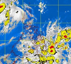
LPA being monitored near General Santos–Pagasa
MANILA, Philippines — A low pressure area near General Santos City is being monitored by the state weather bureau on Friday.
The LPA was last observed 600 kilometers east of General Santos City and was embedded along an intertropical convergence zone affecting Mindanao, the Philippine Atmospheric Geophysical and Astronomical Services Administration said.
Should it intensify into a tropical depression, it will be called “Jolina.”
Meanwhile, a monsoon trough was affecting Northern and Central Luzon.
Pagasa said Mindanao would experience cloudy skies with moderate to occasionally heavy rainshowers and thunderstorms which may trigger flashfloods and landslides.
Article continues after this advertisement“Visayas and the regions of Ilocos, Cordillera, Cagayan and Central Luzon will have cloudy skies with light to moderate rainshowers and thunderstorms,” it added.
Article continues after this advertisementMetro Manila and the rest of Luzon, meanwhile, will be partly cloudy to cloudy with isolated rainshowers or thunderstorms.
“Moderate to occasionally strong winds blowing from the southwest to southeast will prevail over the western section of Northern and Central Luzon and the coastal waters along these areas will be moderate to occasionally rough.
“Light to moderate winds coming from the northeast to southeast will prevail over the rest of Luzon and Visayas and coming from the northeast to northwest over Mindanao.
“The coastal waters along these areas will be with slight to moderate,” Pagasa said. Frances Mangosing
