‘Huaning’ exits

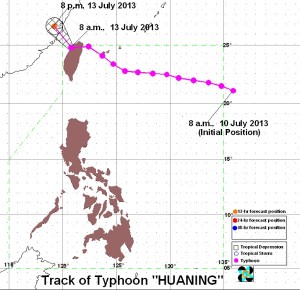
The state weather bureau said the typhoon lost some of its strength after it made landfall over Northern Taiwan, whose area of responsibility with respect to international convention on the monitoring of tropical cyclones overlaps that of the Philippines. At midday Saturday, the typhoon was moving toward Southern China.
As of Saturday morning, the eye of the storm was already some 450 kilometers north of Itbayat, Batanes, according to the Philippine Atmospheric, Geophysical and Astronomical Services Administration (Pagasa).
“Huaning” was packing maximum winds of 140 kilometers per hour near the center and gusting up to 170 kph.
Pagasa predicted it would move northwest at 20 kph.
The public storm signal over the Batanes group of islands has been lifted, the weather bureau said.
Article continues after this advertisementBased on Pagasa’s weather outlook for Sunday, the Batanes group of islands will have rains with gusty winds. Metro Manila and the rest of the country will experience cloudy skies with light to moderate rain showers and thunderstorms, it added.
Article continues after this advertisementModerate to strong winds blowing from the southwest will prevail over the rest of Luzon and the coastal waters along these areas will be moderate to rough, Pagasa said.
Elsewhere, winds will be light to moderate coming from the southwest with slight to moderate seas, it added.
Fishermen especially those using small seacraft were advised not to venture out to sea off Northern and Central Luzon due to big waves generated by the typhoon.