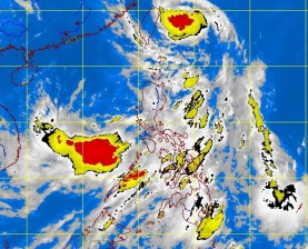
Tropical Strom ‘Emong’ out of PH, but rains to persist
MANILA, Philippines—Tropical Storm “Emong” is on its way out of the country, but the enhanced southwest monsoon (“habagat”) will continue to spawn moderate to heavy rains over Metro Manila on Thursday, the state weather bureau said.
The storm is predicted to leave the country’s area of responsibility by Thursday, according to the Philippine Atmospheric, Geophysical and Astronomical Services Administration (Pagasa).
As Emong departed without making landfall, a new low-pressure area was spotted 550 kilometers west of San Jose, Occidental Mindoro, possibly bringing more monsoon rains, the weather bureau said.
As of 5 p.m. on Wednesday, Emong had maintained its peak winds of 75 kilometers per hour and gusts of up to 90 kph, Pagasa said. Its eye was observed some 370 km northeast of Basco, Batanes.
But Pagasa forecaster Jori Loiz warned that Metro Manila could continue to experience moderate to heavy downpours between 5 a.m. and 8 a.m. Thursday.
Article continues after this advertisementThe rains are expected to persist until 2 p.m., and gradually dissipate by evening, he said.
Article continues after this advertisementIn a briefing at Pagasa Science Garden in Quezon City, Loiz clarified that a “general forecast” of moderate to heavy rains did not necessarily mean that all areas of Metro Manila would experience downpours.
“This is only a general prediction and some areas may only experience light rain,” he said.
For thunderstorms that form rapidly, Pagasa issues advisories via its Twitter and Facebook accounts, Loiz said.
Based on Pagasa’s outlook for today, Luzon will experience cloudy skies with moderate to heavy rain showers and thunderstorms, which may trigger flash floods and landslides.
“The Visayas, Zamboanga Peninsula, Northern Mindanao and Caraga will have cloudy skies with light to moderate rain showers and thunderstorms. The rest of Mindanao will be partly cloudy to cloudy with isolated rain showers or thunderstorms,” it added.
Fishermen, especially those using small seacraft, were advised not to venture out into the northern and eastern seaboards of Luzon, and the western seaboard of southern Luzon due to big waves generated by Emong.
Emong is the second tropical storm to enter the country’s area of responsibility after “Dante,” which hit on June 9 and signaled the start of the rainy season.
Emong is the fifth tropical cyclone to hit the Philippines after “Auring,” “Bising,” and “Crising,” which were tropical depressions, and Dante.
None of the other cyclones made landfall.
