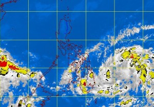
Low pressure area off Surigao Sur may develop into storm
MANILA, Philippines – A low pressure area which could become a cyclone inched closer to the Philippine territory, the state weather bureau said Monday afternoon.
The LPA was last seen 620 kilometers east off Hinatuan City, Surigao del Sur embedded along the Intertropical Convergence Zone (ITCZ) affecting Visayas and Mindanao, the Philippine Atmospheric Geophysical and Astronomical Services Administration said.
Once it develops into a cyclone it will be named Ofel.
Although the LPA is too far to directly affect the country, Visayas and Mindanao will be cloudy with moderate to heavy rainshowers and thunderstorms which may trigger flashfloods and landslides. Bicol region and Mimaropa will have occasional light to moderate rainshowers or thunderstorms. Metro Manila and the rest of Luzon will be partly cloudy with brief rainshowers or thunderstorms, Pagasa said.
Moderate to strong winds blowing from the northeast will prevail over Luzon and Visayas and the coastal waters along these areas will be moderate to rough. Elsewhere, winds will be light to moderate coming from the northeast to north with slight to moderate seas.
