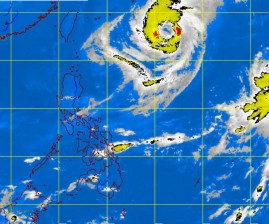
Typhoon ‘Nina’ still around but no rains seen
The Philippine Atmospheric, Geophysical and Astronomical Services Administration (Pagasa) expects “overstaying” Typhoon Nina (international name: Prapiroon) to linger within the country’s area of responsibility until Wednesday as it slowed while moving northeast.
But forecasters said the typhoon would continue to have no effect on the country, which is anticipated to enjoy generally good weather.
As of 4 p.m. Sunday, the eye of Nina was estimated at 865 kilometers east of Itbayat, Batanes, packing maximum sustained winds of 140 kilometers per hour and gustiness of up to 170 kph. The typhoon was moving northeast at 5 kph.
Although no public storm warning signal has been raised, fishing boats and other small sea craft have been advised not to venture into the northern and western seaboards of northern Luzon (Ilocos Norte, Batanes, Ilocos Sur, La Union, Pangasinan) as well as the eastern seaboards (Cagayan, Isabela, Aurora, Quezon and the Bicol region) due to big waves generated by the typhoon.
Pagasa also estimated heavy to intense (10 to 20 mm per hour) rainfall within the 700-km diameter of the typhoon.
Article continues after this advertisementForecaster Samuel Duran said they initially anticipated Nina to leave the Philippine area of responsibility (PAR) by Monday but the typhoon considerably slowed and is poised to stay around longer.
Article continues after this advertisementDuran told the Philippine Daily Inquirer that since Nina remained too far away to have any effect on the country, generally sunny weather would prevail.
Nina entered the PAR on Oct. 8 as a tropical storm and intensified into a typhoon.
The forecaster said there may be brief rainshowers or thunderstorms during the day but generally good weather is anticipated over the whole country.
