Low pressure area intensifies into tropical depression

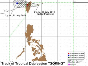
The track of tropical depression 'Goring' as o 2 p.m. Saturday. PAGASA
MANILA, Philippine – The low pressure area off Batanes intensified into a tropical depression, the state weather bureau said Saturday.
Philippine Atmospheric, Geophysical and Astronomical Services Administration (Pagasa) said Saturday.
In its 5 p.m. bulletin, the Philippine Atmospheric, Geophysical and Astronomical Services Administration said that weather disturbance “Goring” was seen 400 kilometers north northeast of Basco, Batanes.
It was packing maximum sustained winds of 55 kilometers per hour and was forecast to move west northwestward at 7 kph.
No storm signals have been raised, Pagasa said.
Article continues after this advertisementGoring is expected to enhance the southwest monsoon which will bring occasional rains over Luzon.
Article continues after this advertisement“Luzon will experience occasional rains becoming frequent over the western section while the rest of the country will have cloudy skies with scattered rainshowers and thunderstorms with widespread rains over Eastern Mindanao which may trigger flashfloods and landslides,” Pagasa warned.
By Sunday afternoon, Goring was expected to be 410 km north of Basco, Batanes or 110 km southwest of Taipei, Taiwan. By Monday, the tropical depression was forecast to be 600 km northwest of Basco, Batanes or 370 km west of Taipei, Taiwan, Pagasa said.
Meanwhile, another low pressure area was seen 320 kilometers east of Hinatuan, Surigao del Sur.