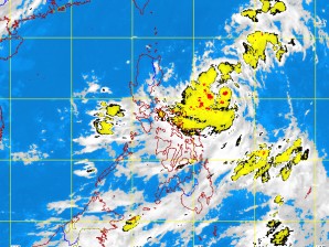
New storm nears PH
MANILA, Philippines—A low pressure area (LPA) was spotted over the Pacific Ocean 1,280 kilometers east of Mindanao on Saturday morning and is forecast to swirl into the Philippine area of responsibility (PAR) Sunday morning.
The LPA will spawn scattered rainshowers and thunderstorms over eastern Visayas and eastern Mindanao Sunday night, weather forecaster Aldczar Aurelio said Saturday.
“The rains will be moderate to heavy. Residents there should be alert for landslides and flashfloods,” he said by phone.
But until Sunday morning, the southwest monsoon will bring occasional rains over the western section of Central and southern Luzon, the Philippine Atmospheric Geophysical and Astronomical Services Administration (Pagasa) said.
Western Visayas will experience mostly cloudy skies with scattered rainshowers and thunderstorms. The rest of the country will be partly cloudy to cloudy with isolated rainshowers or thunderstorms, Pagasa said.
The PAR is the designated area in the northwestern Pacific Ocean where Pagasa monitors tropical cyclone activity.
Article continues after this advertisementMeanwhile, the so-called “leap second” was added to the world’s atomic clocks at midnight last night to keep in step with the slowing rotation of the earth. The atomic clocks are the reference point by which the world sets its watches.
Article continues after this advertisementAccording to reports, the atomic clocks will read 23 hours, 59 minutes and 60 seconds before moving on to midnight Greenwich Mean Time.
“We add the leap second because of the difference between the international atomic time and solar time. The rotation of the earth should be synchronized with the atomic clock. The atomic clock is more stable, while the earth’s rotation changes,” Dario de la Cruz, chief of Pagasa’s Space Sciences and Astronomy Section, said.
