Marce maintains strength over Cagayan waters; Signal No. 3 up in 2 areas

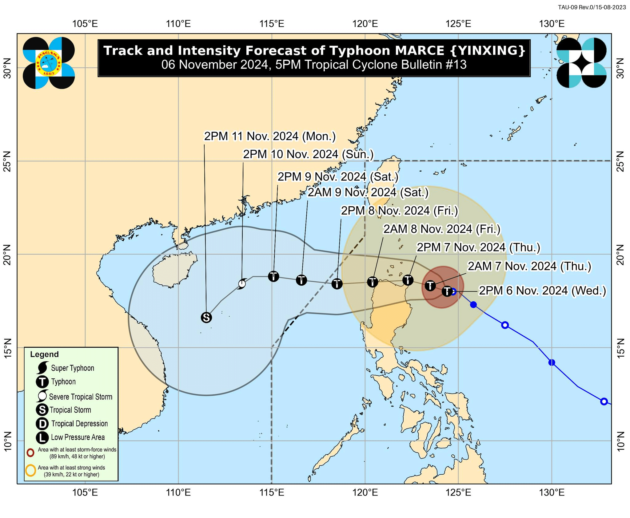
Track and intensity forecast of Typhoon Marce (international name: Yinxing) as of 5 p.m., Wednesday, November 6. Image from DOST-Pagasa / Facebook
MANILA, Philippines — Typhoon Marce (international name: Yinxing) maintained its strength over the Cagayan waters on Wednesday afternoon, prompting Tropical Cyclone Wind Signal (TCWS) No. 3 to remain in two areas in Northern Cagayan, the state weather bureau said.
In its 5 p.m. weather bulletin, the Philippine Atmospheric, Geophysical and Astronomical Services Administration (Pagasa) said that Marce was last spotted east of Aparri, Cagayan, slowly moving westward.
It is still sustaining maximum wind speed of 150 kilometers per hour (kph) and gustiness of up to 185 kph.
READ: Typhoon Marce moving slowly over Cagayan waters; Signal No. 3 in 2 areas
Pagasa said that TCWS No. 3 was raised over the following areas:
- Northern portion of mainland Cagayan (Santa Ana, Gonzaga)
Signal No. 2:
Luzon
- Batanes
- Rest of Cagayan including Babuyan Islands
- Northern portion of Isabela (Maconacon, San Pablo, Santa Maria, Divilacan)
- Apayao
- Northern portion of Kalinga (Rizal, Pinukpuk, Balbalan)
- Northern portion of Abra (Langiden, Bangued, Danglas, Tayum, La Paz, Dolores, Lagayan, San Juan, Lagangilang, Tineg, Lacub, Licuan-Baay, Malibcong)
- Ilocos Norte
- Northern portion of Ilocos Sur (Sinait, Cabugao, San Juan, Magsingal, Santo Domingo, Bantay, San Ildefonso, San Vicente, Santa Catalina)
Signal No.1:
Luzon
- Rest of Ilocos Sur
- La Union
- Northwestern portion of Pangasinan (Bani, Bolinao, Anda, City of Alaminos, Agno, Sual)
- Rest of Abra
- Rest of Kalinga
- Mountain Province
- Ifugao
- Benguet
- Rest of Isabela
- Quirino
- Nueva Vizcaya
- Northern portion of Aurora (Dilasag, Casiguran, Dinalungan, Dipaculao, Maria Aurora, Baler)
Further, Pagasa noted that “Marce is expected to continue intensifying and may reach its peak intensity today before its passage over the Babuyan Channel.”
The typhoon is also forecast to make landfall and pass through Babuyan Islands and/or the northern portion of mainland Cagayan, Ilocos Norte, and Apayao from Thursday afternoon to Friday early morning.
READ: 154 killed, over 8.8 million affected by Kristine and Leon – NDRRMC
Meanwhile, storm surge warning is up in the next 48 hours over the low-lying or coastal communities of the following:
- Batanes
- Cagayan including Babuyan Islands
- Isabela
- Ilocos Norte
- Ilocos Sur
- La Union
A gale warning is also raised over the seaboards of Northern Luzon and the eastern seaboard of Central Luzon.