Queenie turns into tropical storm as it enters PH
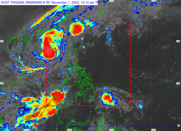
MANILA, Philippines — Another weather disturbance has entered the Philippine area of responsibility (PAR) just as Severe Tropical Storm Paeng (international name: Nalgae) left the country Monday morning, according to the state weather bureau.
The Philippine Atmospheric, Geophysical and Astronomical Services Administration (Pagasa) said the low pressure area it was monitoring last week entered PAR at 5 a.m. and intensified into a tropical storm at 8 a.m. on Monday.
Named Queenie, Pagasa said it was expected to further strengthen as it moves over water toward northeastern Mindanao.
Based on its latest track and intensity forecast, Pagasa said Queenie was last plotted 815 kilometers east of northeastern Mindanao, packing maximum winds of 65 kilometers per hour near the center and gusts of up to 80 kph and moving southwestward at 10 kph.
Based on Pagasa’s forecast, the tropical storm is unlikely to directly affect the country until Tuesday and may even weaken by Friday.
Article continues after this advertisementHowever, light to moderate with at times heavy rains are expected over the Caraga Administrative Region (northeastern section of Mindanao), Eastern Visayas, and Bicol on Wednesday.
Article continues after this advertisement
COME HELL OR HIGH WATER | A mother and her two children are among the few people who brave the floods triggered by storm Paeng (Nalgae) so they can visit their departed relatives on Monday, the eve of All Saints’ Day, at Holy Spirit Memorial Park in Masantol, Pampanga. (Photo by GRIG C. MONTEGRANDE / Philippine Daily Inquirer)
“Based on the latest forecast scenario, tropical cyclone wind signal may be hoisted over the eastern portion of Caraga and in some areas in Eastern Visayas tomorrow evening at the earliest,” Pagasa said.
It added that over the next 24 hours, Queenie was less likely to bring rough seas over the country’s coastal waters that could result in risky conditions for seafarers.
Queenie is forecast to move across the country westward before turning generally northwestward from Tuesday morning through Wednesday morning.
Wind signal
By Wednesday afternoon, this storm will head northwestward toward Caraga-Eastern Visayas area.No tropical wind signal is hoisted as of Monday, but the highest it may reach is Wind Signal No. 1. Queenie is the 17th tropical depression to enter PAR this year and the fifth for the month of October, including Typhoons Neneng and Obet.
This is not the first time that the Philippines is experiencing back-to-back cyclones during the typhoon season.
In 2020, the country was hit by successive storms that ravaged agriculture and infrastructure. Within just a month’s time — between Oct. 11 and Nov. 12 — eight cyclones entered PAR, with all but one making landfall. These included Typhoons Pepito and Quinta, Supertyphoon Rolly, and Typhoon Ulysses, which brought heavy flooding in Metro Manila, nearby towns of Rizal province, Central Luzon, and Cagayan Valley.
RELATED STORIES
All signals down as Paeng moves away; Queenie keeps strength
Queenie may weaken but will continue to bring rain to most parts of PH
Paeng deaths rise to 101; over 2 million persons affected
Responding to appeals for help, the Inquirer is extending its relief efforts to the families affected by Typhoon Paeng. Cash donations may be deposited in the Inquirer Foundation Corp. Banco De Oro (BDO) Current Account No.: 007960018860 and through Maya

