Paeng advances: 6 areas under Signal No. 2, 17 others under Signal No. 1
MANILA, Philippines — State meteorologists placed six areas in the country under Signal no. 2 and 17 others under Signal no. 1 as Tropical Storm Paeng (international name: Nalgae) nears the Philippine landmass on Friday.
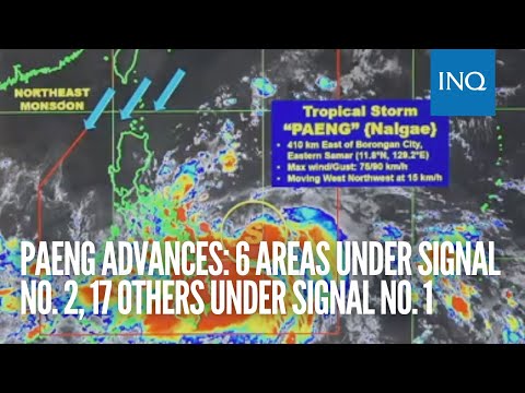
The Philippine Atmospheric, Geophysical and Astronomical Services Administration (Pagasa) said Paeng was last located 410 kilometers east of Borongan City, Eastern Samar, packing maximum sustained winds of 75 kilometers per hour (kph) and gustiness of 90 kph. Its latest direction was west-northwest at 15 kph.
Based on Pagasa’s 5 a.m. weather bulletin, a Tropical Cyclone Wind Signal (TCWS) is hoisted over the following areas:
Signal No. 2
- Catanduanes
- Albay
- Sorsogon
- Eastern portion of Camarines Sur (Caramoan, Garchitorena, Presentacion, Lagonoy, Goa, San Jose, Tigaon, Iriga City, Saglay, Buhi)
- Northern Samar
- Northern portion of Eastern Samar (Jipapad, Arteche, Oras, San Policarpo, Maslog, Dolores, Can-Avid, Taft)
Signal No. 1
- Masbate, including Ticao and Burias Islands
- Camarines Norte
- Rest of Camarines Sur
- Romblon
- Marinduque
- Quezon, including Polillo Islands
- Laguna
- Rizal
- Samar
- Rest of Eastern Samar
- Biliran
- Leyte
- Southern Leyte
- Northern portion of Cebu (Daanbantayan, Medellin, San Remigio, Tabogon, City of Bogo, Borbon) including Bantayan and Camotes Islands
- Dinagat Islands
- Surigao del Norte, including Siargao and Bucas Grande Islands
- Northern portion of Surigao del Sur (Carrascal, Cantilan, Madrid, Carmen, Lanuza, Cortes, City of Tandag, Bayabas, Tago, Cagwait)
“Winds may reach gale-force strength during the passage of Paeng within any of the areas where Tropical Cyclone Wind Signal No. 2 is hoisted. Strong winds may be experienced within any of the areas where Tropical Cyclone Wind Signal No. 1 is hoisted throughout the entire passage of Paneg,” Pagasa explained.
Rain is also expected to prevail over a large portion of the country due to Paeng’s size, according to Pagasa weather specialist Benison Estreja.
“Nakakaapekto na itong malalakas na ulan dulot ni Paeng sa Visayas, and Mindanao, maging dito rin po sa Bicol Region and Mimaropa. Sa mga sususnod na oras, makakaranas na rin ng pag-ulan ang ilang bahagi ng Calabarzon, itong Metro Manila, and Aurora, hanggang dito sa Cagayan and Isabela, dahil po sa paglapit ni Bagyong Paeng at dun na rin sa trough na tinatawag,” Estreja said during Pagasa’s weather report early Friday.
(Heavy rains caused by Paeng are affecting Visayas and Mindanao, as well as the Bicol Region and Mimaropa. In the coming hours, rain will prevail in some parts of Calabarzon, Metro Manila and Aurora, all the way to Cagayan and Isabela, as Tropical Storm Paeng approaches and also due to its so-called trough.)
The state weather bureau then warned that areas affected by rain may see landslides and floods.
As for the rest of Luzon, Estreja said it will be less cloudy and likely cold due to the prevailing northeast monsoon, locally termed “amihan,” which is seen to also bring scattered rain showers in some areas.
Meanwhile, Pagasa’s latest tracking of Paeng has indicated that the tropical storm may hit Catanduanes or pass very close to the province by Saturday morning, October 29. Paeng is also predicted to make landfall near Quezon’s Polillo Islands by Saturday afternoon.
Before that, however, Paeng is anticipated to develop into a severe tropical storm by late Friday afternoon and further strengthen into a typhoon by Saturday dawn due to the warm temperature of the Philippine Sea.
By Sunday, October 30, Paeng is expected to cross between Northern and Central Luzon, possibly directly affecting Calabarzon, Metro Manila, Central Luzon, and even Cagayan Valley, Cordillera Administrative Region, and Ilocos Region.
Pagasa further said that a gale warning was raised over the coasts of Ilocos Norte, Ilocos Sur, La Union, Pangasinan, Batanes, Cagayan and the Babuyan Islands, Aurora, Isabela, north and east portion of Quezon and the Polillo Islands, Camarines Norte, north Camarines Sur, Catanduanes, east coast of Albay, east coast of Sorsogon, Northern Samar, and Eastern Samar.
RELATED STORIES
14 areas under Wind Signal No. 1 due to Paeng
Paeng may make landfall in Aurora, Quezon province; Signal No. 1 up in more areas
Responding to appeals for help, the Inquirer is extending its relief efforts to the families affected by Typhoon Paeng. Cash donations may be deposited in the Inquirer Foundation Corp. Banco De Oro (BDO) Current Account No.: 007960018860 and through Maya