TD Agaton now in Marabut, Samar; Signal No. 1 still up in 9 areas
Source: DOST / Pagasa
MANILA, Philippines — The center of Tropical Depression Agaton is now in the vicinity of Marabut, Samar as nine areas are still under Tropical Cyclone Wind Signal (TCWS) No. 1, the Philippine Atmospheric, Geophysical and Astronomical Services Administration (Pagasa) said Tuesday morning.
In its 8 a.m. bulletin, Pagasa said the following areas are placed under TCWS No. 1:
Luzon
– Southern portion of Masbate (Dimasalang, Cawayan, Palanas, Placer, Cataingan, Esperanza, Pio V. Corpuz)
Visayas
– Eastern Samar
– Samar
– Northern Samar
– Biliran
– Leyte
– Southern Leyte
– northeastern portion of Cebu (Daanbantayan, Medellin, City of Bogo, Tabogon, Borbon, Sogod) including Camotes Island
Mindanao
– Dinagat Islands
Article continues after this advertisementUnder TCWS No. 1, strong winds are prevailing or expected within the next 36 hours and could pose a “minimal to minor” threat to life and property.
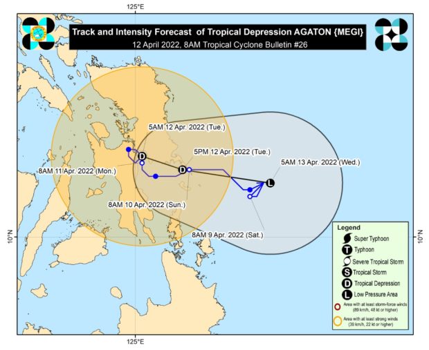
According to Pagasa, Agaton currently packs maximum sustained winds of 45 kilometers per hour (kph) near the center and gustiness of up to 75 kph. The tropical cyclone is slowly moving eastward.
Rainfall warning
For Tuesday, Pagasa said moderate to heavy with at times intense rains are expected over Eastern Visayas, Bicol Region, the northern and central portions of Cebu including Bantayan and Camotes Islands, Aklan, Capiz, Iloilo, Antique, Guimaras, and the northern and central portions of Negros Provinces.
Meanwhile, light to moderate with at times heavy rains will prevail in Mimaropa, Dinagat Islands, Zamboanga del Norte, Quezon, and the rest of Visayas.
“Under these conditions and considering significant antecedent rainfall, scattered to widespread flooding (including flooding) and rain-induced landslides are still expected especially in areas that are highly or very highly susceptible to these hazards as identified in hazard maps,” said Pagasa.
Strong winds, or strong breeze to near gale conditions, will also be experienced within any of the areas where TCWS No. 1 is currently in effect.
Forecast track
Agaton is forecast to continue meandering in the vicinity of Samar-Leyte area within the next 6 to 12 hours before turning more east southeastward towards the Philippine Sea starting Tuesday night or Tuesday morning, according to Pagasa.
“Considering the continuing erratic nature of its movement, the track forecast of ‘Agaton’ may likely change in the succeeding bulletins,” the agency added.
“Due to the combined effects of land interaction, increasing vertical wind shear, and the effects of the upper-level outflow of Severe Tropical Storm ‘Malakas,’ this tropical depression is forecast to deteriorate into a remnant low within the next 24 hours,” said Pagasa.
Pagasa said the remnant of Agaton will then continue moving generally eastward over the Philippine Sea “as it becomes assimilated” within the circulation of Malakas.
RELATED STORIES:
Landfall scenario still unlikely for severe tropical storm outside PAR
Agaton weakens but may still bring heavy rain over Visayas — Pagasa