Fabian maintains strength; continues slow movement toward west—Pagasa
Track of typhoon Fabian from Pagasa website
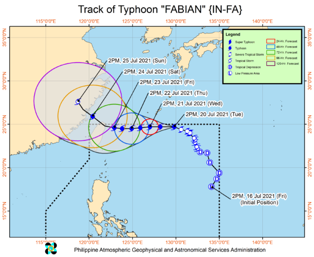
MANILA, Philippines — Typhoon Fabian remains within the Philippine area of responsibility (PAR) as it still moves west in a slow manner, state meteorologists said on Thursday afternoon.
The latest weather bulletin from the Philippine Atmospheric, Geophysical and Astronomical Services Administration (Pagasa) showed that Fabian was able to maintain its strength, packing maximum sustained winds of 150 kilometers per hour (kph) near the center, and gustiness of up to 185 kph.
Fabian’s eye was last seen around 505 kilometers northeast of Itbayat, Batanes, with strong winds extending outwards up to 630 kilometers from the center.
As of now, Tropical Cyclone Wind Signal No. 1 is still raised over Batanes and Babuyan Islands, as these areas may still experience strong winds in the next 36 hours.
Similar to before, Fabian is still not expected to directly hit any part of the country’s landmass, but it may intensify the effects of the southwest monsoon or habagat.
Article continues after this advertisementAs a result, Pagasa says that monsoon rains would prevail over Ilocos Region, Abra, Benguet, Zambales, Bataan, Tarlac, Pampanga, Bulacan, Metro Manila, Calabarzon, Occidental Mindoro, Oriental Mindoro, Marinduque, Romblon, and the northern portion of Palawan including Calamian and Kalayaan Islands.
Article continues after this advertisementPagasa predicts that Fabian would start shifting northwest on Friday afternoon, before it leaves the PAR on early Saturday morning. During this time, the typhoon may reach its peak intensity as it may pack maximum sustained winds of 165 kph.
By Sunday morning it would be around 870 kilometers north of Itbayat, and would start to gradually weaken as it approaches eastern portions of China.
“On the forecast track, the typhoon will pass close or make landfall in the vicinity of Miyako, Yaeyama, and Senkaku Islands in the southern Ryukyu Archipelago between tomorrow (23 July) afternoon and Saturday (24 July) morning,” Pagasa said.
Due to the strong winds, gale warnings are also raised over the entire seaboards of Luzon and Visayas, which means sea travel for small sea craft would be risky.
RELATED STORY:
Typhoon Fabian keeps strength; monsoon rain to continue over Metro Manila, parts of Luzon